Vreshtas geodata
Vreshtas (Korçë) is a seat of a third-order administrative division; located in Albania in Europe/Tirane (GMT+2) time zone. In our database, there are 71 cities with bigger population. Compared to other cities in Albania, 64.2% of cities are located further ↑North; 97.2% of cities are located further ←West and 85.9% of cities have lower elevation than Vreshtas. Note1


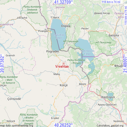
Vreshtas GPS coordinates[2]
40° 47' 48.984" North, 20° 46' 36.984" East
| Map corner | latitude | longitude |
|---|---|---|
| Upper-left | 41.32709°, | 20.07382° |
| Center: | 40.79694°, | 20.77694° |
| Lower-right: | 40.26252°, | 21.48007° |
| Map W x H: | 118.4×118.4 km | = 73.6×73.6mi |
| max Lat: | 42.45139° ⇑64.2% North |
| Vreshtas: | 40.79694° |
| min Lat: | ⇓35.8% South 39.65889° |
| min Long | Vreshtas | max Long |
| 19.40556° | 20.77694° | 20.99° |
| W 97.2%⇐ | ⇒2.8% E |
Elevation
Elevation of Vreshtas is 818 m = 2684 ft, and this is 443.4 m = 1455 ft above average elevation for this country.
| Max E: |
1352 m = 4436 ft | 14.1% |
| Vreshtas | 818 m 2684 ft | |
| Avg. | 374.6 m = 1229 ft | |
Min E: |
-2 m = -7 ft | 85.9% |
See also: Albania elevation on elevation.city.
Geographical zone
Vreshtas is located in North temperate zone (between Tropic of Cancer and the Arctic Circle). Distance of this Northern Tropic circle is 1930.3 km =1199.4 mi to South.| Distance of | km | miles | from Vreshtas |
|---|---|---|---|
| North Pole | 5470.9 | 3399.5 | to North |
| Arctic Circle | 2865 | 1780.2 | to North |
| Tropic Cancer | 1930.3 | 1199.4 | to South |
| Equator | 4536.2 | 2818.7 | to South |


Nearby cities:
15 places around Vreshtas: (largest is in red/bold)
• Buçimas
13.2 km =8.2 mi,  322°
322°
• Cerava
7.5 km =4.7 mi, 324°
• Dardhas
11.4 km =7.1 mi,  298°
298°
• Dishnicë
16.5 km =10.3 mi,  169°
169°
• Korçë
19.8 km =12.3 mi,  179°
179°
• Libonik
11.8 km =7.3 mi,  209°
209°
• Liqenas
10.6 km =6.6 mi,  96°
96°
• Maliq
12 km =7.5 mi, 212°
• Mborje
21.6 km =13.4 mi, 174°
• Novoselë
7.7 km =4.8 mi,  239°
239°
• Pirg
6.1 km =3.8 mi,  257°
257°
• Pogradec
15.7 km =9.8 mi, 318°
• Pojan
9.4 km =5.8 mi,  147°
147°
• Progër
17.9 km =11.1 mi,  129°
129°
• Voskop
21.8 km =13.5 mi,  199°
199°
Sources, notices
• [Note1] Compared only with cities in Albania existing in our database
• [Src1] Map data: © OpenStreetMap contributors (CC-BY-SA)
• [Src2] Other city data from geonames.org with taken over terms of usage.
• [Src3] Geographical zone / Annual Mean Temperature by Robert A. Rohde @ Wikipedia
