Aygestan geodata
Aygestan (Ararat) is a populated place; located in Armenia in Asia/Yerevan (GMT+4) time zone. With population of 2,431 people, there are 122 cities with bigger population in this country. Compared to other cities in Armenia, 82.5% of cities are located further ↑North; 52.5% of cities are located further ←West and 72.3% of cities have higher elevation than Aygestan. Note1


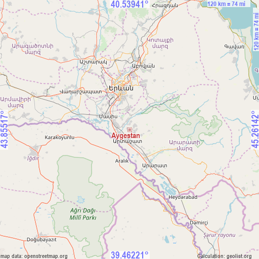
Aygestan GPS coordinates[2]
40° 0' 10.548" North, 44° 33' 29.844" East
| Map corner | latitude | longitude |
|---|---|---|
| Upper-left | 40.53941°, | 43.85517° |
| Center: | 40.00293°, | 44.55829° |
| Lower-right: | 39.46221°, | 45.26142° |
| Map W x H: | 119.8×119.8 km | = 74.4×74.4mi |
| max Lat: | 41.24358° ⇑82.5% North |
| Aygestan: | 40.00293° |
| min Lat: | ⇓17.5% South 38.90292° |
| min Long | Aygestan | max Long |
| 43.74722° | 44.55829° | 46.5446° |
| W 52.5%⇐ | ⇒47.5% E |
Elevation
Elevation of Aygestan is 869 m = 2851 ft, and this is 432.5 m = 1419 ft below average elevation for this country.
| Max E: |
2169 m = 7116 ft | 72.3% |
| Avg. | 1301.5 m = 4270 ft | |
| Aygestan | 869 m = 2851 ft | |
Min E: |
440 m = 1444 ft | 27.7% |
See also: Armenia elevation on elevation.city.
Geographical zone
Aygestan is located in North temperate zone (between Tropic of Cancer and the Arctic Circle). Distance of this Northern Tropic circle is 1842 km =1144.6 mi to South.| Distance of | km | miles | from Aygestan |
|---|---|---|---|
| North Pole | 5559.2 | 3454.3 | to North |
| Arctic Circle | 2953.3 | 1835.1 | to North |
| Tropic Cancer | 1842 | 1144.6 | to South |
| Equator | 4447.9 | 2763.8 | to South |


Nearby cities:
15 places around Aygestan: (largest is in red/bold)
• Abovyan
5.2 km =3.2 mi,  349°
349°
• Arevshat
4.3 km =2.7 mi,  341°
341°
• Artashat
4.8 km =3 mi,  194°
194°
• Berk’anush
4.5 km =2.8 mi,  231°
231°
• Byuravan
3.7 km =2.3 mi,  293°
293°
• Dalar
4 km =2.5 mi,  222°
222°
• Dvin
2.9 km =1.8 mi,  49°
49°
• Getazat
4 km =2.5 mi,  6°
6°
• Mrganush
2.9 km =1.8 mi,  0°
0°
• Mrgavan
3.9 km =2.4 mi,  209°
209°
• Norashen
3 km =1.9 mi,  93°
93°
• Nshavan
3.9 km =2.4 mi,  314°
314°
• Verin Artashat
2.7 km =1.7 mi,  103°
103°
• Verin Dvin
3.6 km =2.2 mi, 48°
• Vostan
4.2 km =2.6 mi,  178°
178°
Sources, notices
• [Note1] Compared only with cities in Armenia existing in our database
• [Src1] Map data: © OpenStreetMap contributors (CC-BY-SA)
• [Src2] Other city data from geonames.org with taken over terms of usage.
• [Src3] Geographical zone / Annual Mean Temperature by Robert A. Rohde @ Wikipedia
