Villa de Mayo geodata
Villa de Mayo (Buenos Aires) is a populated place; located in Argentina in America/Argentina/Buenos_Aires (GMT-3) time zone. With population of 43,405 people, there are 101 cities with bigger population in this country. Compared to other cities in Argentina, 71.9% of cities are located further ↑North; 80.9% of cities are located further ←West and 95.7% of cities have higher elevation than Villa de Mayo. Note1


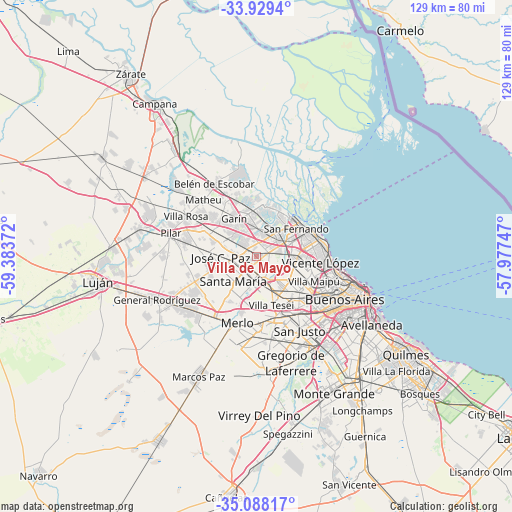
Villa de Mayo GPS coordinates[2]
34° 30' 38.88" South, 58° 40' 50.124" West
| Map corner | latitude | longitude |
|---|---|---|
| Upper-left | -33.9294°, | -59.38372° |
| Center: | -34.5108°, | -58.68059° |
| Lower-right: | -35.08817°, | -57.97747° |
| Map W x H: | 128.8×128.8 km | = 80×80mi |
| max Lat: | -21.94467° ⇑71.9% North |
| Villa de Mayo: | -34.5108° |
| min Lat: | ⇓28.1% South -54.81084° |
| min Long | Villa de Mayo | max Long |
| -72.88605° | -58.68059° | -53.64581° |
| W 80.9%⇐ | ⇒19.1% E |
Elevation
Elevation of Villa de Mayo is 16 m = 52 ft, and this is 333.3 m = 1094 ft below average elevation for this country.
| Max E: |
4040 m = 13255 ft | 95.7% |
| Avg. | 349.3 m = 1146 ft | |
| Villa de Mayo | 16 m = 52 ft | |
Min E: |
-2 m = -7 ft | 4.3% |
See also: Villa de Mayo elevation on elevation.city.
Geographical zone
Villa de Mayo is located in South temperate zone (between Tropic of Capricorn and the Antarctic Circle). Distance of this Southern Tropic circle is 1231.3 km =765.1 mi to North.| Distance of | km | miles | from Villa de Mayo |
|---|---|---|---|
| Equator | 3837.2 | 2384.3 | to North |
| Tropic Capricorn | 1231.3 | 765.1 | to North |
| Antarctic Circle | 3563.9 | 2214.5 | to South |
| South Pole | 6169.8 | 3833.7 | to South |


Nearby cities:
15 places around Villa de Mayo: (largest is in red/bold)
• Caseros
14.8 km =9.2 mi,  133°
133°
• Don Torcuato
5.2 km =3.2 mi,  69°
69°
• General Pacheco
7.3 km =4.5 mi,  27°
27°
• General San Martín
15.1 km =9.4 mi,  117°
117°
• Hurlingham
10 km =6.2 mi,  151°
151°
• Ingeniero Pablo Nogués
4.4 km =2.7 mi,  327°
327°
• Ituzaingó
16.4 km =10.2 mi,  174°
174°
• José C. Paz
8 km =5 mi,  266°
266°
• Los Polvorines
2.5 km =1.6 mi,  290°
290°
• Muñiz
5.6 km =3.5 mi,  205°
205°
• San Isidro
14.7 km =9.1 mi, 72°
• San Miguel
4.6 km =2.9 mi,  218°
218°
• Santa Catalina - Dique Lujan
14.3 km =8.9 mi,  350°
350°
• Tigre
13.2 km =8.2 mi,  44°
44°
• Tortuguitas
7.8 km =4.8 mi,  300°
300°
Sources, notices
• [Note1] Compared only with cities in Argentina existing in our database
• [Src1] Map data: © OpenStreetMap contributors (CC-BY-SA)
• [Src2] Other city data from geonames.org with taken over terms of usage.
• [Src3] Geographical zone / Annual Mean Temperature by Robert A. Rohde @ Wikipedia
