Tigre geodata
Tigre (Buenos Aires) is a populated place; located in Argentina in America/Argentina/Buenos_Aires (GMT-3) time zone. With population of 31,106 people, there are 134 cities with bigger population in this country. Compared to other cities in Argentina, 70.6% of cities are located further ↑North; 82.3% of cities are located further ←West and 98.7% of cities have higher elevation than Tigre. Note1


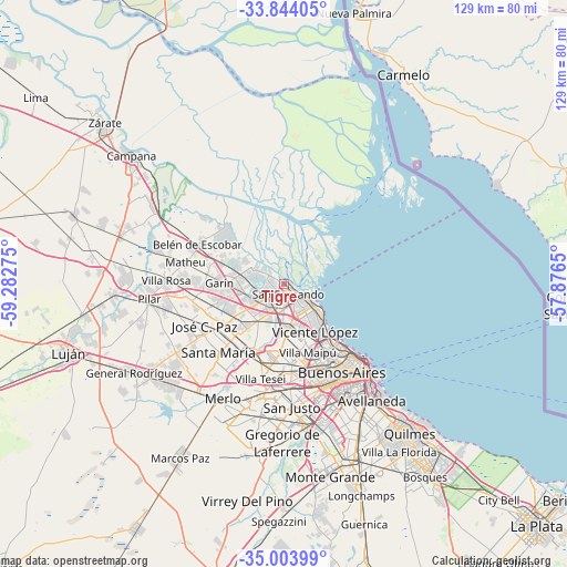
Tigre GPS coordinates[2]
34° 25' 33.708" South, 58° 34' 46.632" West
| Map corner | latitude | longitude |
|---|---|---|
| Upper-left | -33.84405°, | -59.28275° |
| Center: | -34.42603°, | -58.57962° |
| Lower-right: | -35.00399°, | -57.8765° |
| Map W x H: | 129×129 km | = 80.2×80.2mi |
| max Lat: | -21.94467° ⇑70.6% North |
| Tigre: | -34.42603° |
| min Lat: | ⇓29.4% South -54.81084° |
| min Long | Tigre | max Long |
| -72.88605° | -58.57962° | -53.64581° |
| W 82.3%⇐ | ⇒17.7% E |
Elevation
Elevation of Tigre is 8 m = 26 ft, and this is 341.3 m = 1120 ft below average elevation for this country.
| Max E: |
4040 m = 13255 ft | 98.7% |
| Avg. | 349.3 m = 1146 ft | |
| Tigre | 8 m = 26 ft | |
Min E: |
-2 m = -7 ft | 1.3% |
See also: Argentina elevation on elevation.city.
Geographical zone
Tigre is located in South temperate zone (between Tropic of Capricorn and the Antarctic Circle). Distance of this Southern Tropic circle is 1221.9 km =759.3 mi to North.| Distance of | km | miles | from Tigre |
|---|---|---|---|
| Equator | 3827.8 | 2378.5 | to North |
| Tropic Capricorn | 1221.9 | 759.3 | to North |
| Antarctic Circle | 3573.4 | 2220.4 | to South |
| South Pole | 6179.2 | 3839.6 | to South |


Nearby cities:
15 places around Tigre: (largest is in red/bold)
• Belgrano
18.8 km =11.7 mi,  143°
143°
• Caseros
19.8 km =12.3 mi,  175°
175°
• Don Torcuato
8.8 km =5.5 mi,  209°
209°
• General Pacheco
6.5 km =4 mi,  243°
243°
• General San Martín
17 km =10.6 mi,  166°
166°
• Hurlingham
18.8 km =11.7 mi,  193°
193°
• Ingeniero Pablo Nogués
13 km =8.1 mi, 243°
• Los Polvorines
14.4 km =8.9 mi,  233°
233°
• Muñiz
18.6 km =11.6 mi,  218°
218°
• Olivos
12.4 km =7.7 mi, 136°
• San Isidro
7 km =4.3 mi, 136°
• San Miguel
17.8 km =11.1 mi, 222°
• Santa Catalina - Dique Lujan
12.6 km =7.8 mi,  291°
291°
• Tortuguitas
16.9 km =10.5 mi,  251°
251°
• Villa de Mayo
13.2 km =8.2 mi, 224°
Sources, notices
• [Note1] Compared only with cities in Argentina existing in our database
• [Src1] Map data: © OpenStreetMap contributors (CC-BY-SA)
• [Src2] Other city data from geonames.org with taken over terms of usage.
• [Src3] Geographical zone / Annual Mean Temperature by Robert A. Rohde @ Wikipedia
