Senillosa geodata
Senillosa (Neuquen) is a populated place; located in Argentina in America/Argentina/Salta (GMT-3) time zone. With population of 6,394 people, there are 391 cities with bigger population in this country. Compared to other cities in Argentina, 92% of cities are located further ↑North; 91.6% of cities are located further →East and 66.7% of cities have lower elevation than Senillosa. Note1


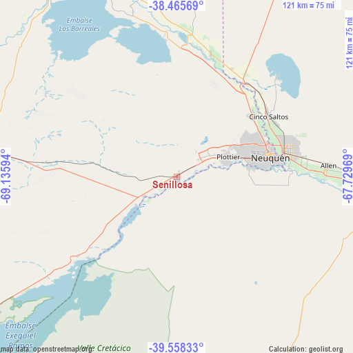
Senillosa GPS coordinates[2]
39° 0' 50.832" South, 68° 25' 58.116" West
| Map corner | latitude | longitude |
|---|---|---|
| Upper-left | -38.46569°, | -69.13594° |
| Center: | -39.01412°, | -68.43281° |
| Lower-right: | -39.55833°, | -67.72969° |
| Map W x H: | 121.5×121.5 km | = 75.5×75.5mi |
| max Lat: | -21.94467° ⇑92% North |
| Senillosa: | -39.01412° |
| min Lat: | ⇓8% South -54.81084° |
| min Long | Senillosa | max Long |
| -72.88605° | -68.43281° | -53.64581° |
| W 8.4%⇐ | ⇒91.6% E |
Elevation
Elevation of Senillosa is 294 m = 965 ft, and this is 55.3 m = 181 ft below average elevation for this country.
| Max E: |
4040 m = 13255 ft | 33.3% |
| Avg. | 349.3 m = 1146 ft | |
| Senillosa | 294 m = 965 ft | |
Min E: |
-2 m = -7 ft | 66.7% |
See also: Argentina elevation on elevation.city.
Geographical zone
Senillosa is located in South temperate zone (between Tropic of Capricorn and the Antarctic Circle). Distance of this Southern Tropic circle is 1732 km =1076.2 mi to North.| Distance of | km | miles | from Senillosa |
|---|---|---|---|
| Equator | 4338 | 2695.5 | to North |
| Tropic Capricorn | 1732 | 1076.2 | to North |
| Antarctic Circle | 3063.2 | 1903.4 | to South |
| South Pole | 5669.1 | 3522.6 | to South |


Nearby cities:
15 places around Senillosa: (largest is in red/bold)
• Allen
52.5 km =32.6 mi,  85°
85°
• Añelo
79.6 km =49.5 mi,  337°
337°
• Centenario
33.2 km =20.6 mi,  51°
51°
• Cervantes
89.8 km =55.8 mi, 92°
• Cinco Saltos
38.5 km =23.9 mi,  56°
56°
• Cipolletti
39.3 km =24.4 mi,  76°
76°
• Contraalmirante Cordero
40.3 km =25 mi,  36°
36°
• Cutral-Có
69.5 km =43.2 mi,  277°
277°
• General Fernández Oro
44.4 km =27.6 mi, 81°
• General Roca
73.4 km =45.6 mi, 91°
• Neuquén
33 km =20.5 mi, 77°
• Picún Leufú
92.4 km =57.4 mi,  232°
232°
• Plaza Huincul
67.8 km =42.1 mi, 278°
• Plottier
18 km =11.2 mi,  72°
72°
• Vista Alegre
36.5 km =22.7 mi, 36°
Sources, notices
• [Note1] Compared only with cities in Argentina existing in our database
• [Src1] Map data: © OpenStreetMap contributors (CC-BY-SA)
• [Src2] Other city data from geonames.org with taken over terms of usage.
• [Src3] Geographical zone / Annual Mean Temperature by Robert A. Rohde @ Wikipedia
