Icaño geodata
Icaño (Catamarca) is a populated place; located in Argentina in America/Argentina/Catamarca (GMT-3) time zone. With population of 6,857 people, there are 370 cities with bigger population in this country. Compared to other cities in Argentina, 69.2% of cities are located further ↓South; 75.8% of cities are located further →East and 70.9% of cities have lower elevation than Icaño. Note1


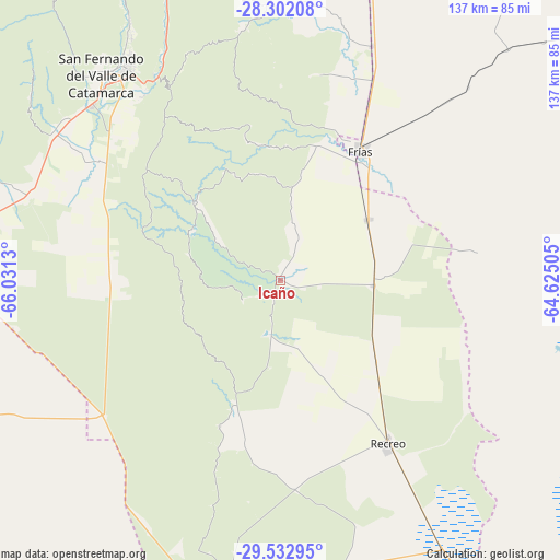
Icaño GPS coordinates[2]
28° 55' 9.624" South, 65° 19' 41.412" West
| Map corner | latitude | longitude |
|---|---|---|
| Upper-left | -28.30208°, | -66.0313° |
| Center: | -28.91934°, | -65.32817° |
| Lower-right: | -29.53295°, | -64.62505° |
| Map W x H: | 136.9×136.9 km | = 85.1×85.1mi |
| max Lat: | -21.94467° ⇑30.8% North |
| Icaño: | -28.91934° |
| min Lat: | ⇓69.2% South -54.81084° |
| min Long | Icaño | max Long |
| -72.88605° | -65.32817° | -53.64581° |
| W 24.2%⇐ | ⇒75.8% E |
Elevation
Elevation of Icaño is 358 m = 1175 ft, and this is 8.7 m = 29 ft above average elevation for this country.
| Max E: |
4040 m = 13255 ft | 29.1% |
| Icaño | 358 m 1175 ft | |
| Avg. | 349.3 m = 1146 ft | |
Min E: |
-2 m = -7 ft | 70.9% |
See also: Argentina elevation on elevation.city.
Geographical zone
Icaño is located in South temperate zone (between Tropic of Capricorn and the Antarctic Circle). Distance of this Southern Tropic circle is 609.6 km =378.8 mi to North.| Distance of | km | miles | from Icaño |
|---|---|---|---|
| Equator | 3215.5 | 1998 | to North |
| Tropic Capricorn | 609.6 | 378.8 | to North |
| Antarctic Circle | 4185.6 | 2600.8 | to South |
| South Pole | 6791.5 | 4220 | to South |


Nearby cities:
15 places around Icaño: (largest is in red/bold)
• Ancasti
20.6 km =12.8 mi,  305°
305°
• Bañado de Ovanta
90.5 km =56.2 mi,  0°
0°
• Capayán
71.9 km =44.7 mi,  282°
282°
• Chumbicha
88.6 km =55.1 mi,  274°
274°
• El Alto
67.7 km =42.1 mi,  357°
357°
• El Rodeo
94.7 km =58.8 mi,  325°
325°
• Frías
36.9 km =22.9 mi,  31°
31°
• Huillapima
66.9 km =41.6 mi,  288°
288°
• La Merced
91.3 km =56.7 mi,  339°
339°
• La Puerta
94.7 km =58.8 mi, 331°
• Los Altos
98.3 km =61.1 mi,  350°
350°
• Recreo
47.9 km =29.8 mi,  147°
147°
• San Fernando del Valle de Catamarca
67 km =41.6 mi,  318°
318°
• San Isidro
63.9 km =39.7 mi, 322°
• San José
69.8 km =43.4 mi, 328°
Sources, notices
• [Note1] Compared only with cities in Argentina existing in our database
• [Src1] Map data: © OpenStreetMap contributors (CC-BY-SA)
• [Src2] Other city data from geonames.org with taken over terms of usage.
• [Src3] Geographical zone / Annual Mean Temperature by Robert A. Rohde @ Wikipedia
