General Enrique Godoy geodata
General Enrique Godoy (Rio Negro) is a populated place; located in Argentina in America/Argentina/Salta (GMT-3) time zone. With population of 3,823 people, there are 500 cities with bigger population in this country. Compared to other cities in Argentina, 92.5% of cities are located further ↑North; 86.8% of cities are located further →East and 59.6% of cities have lower elevation than General Enrique Godoy. Note1
Current local time in General Enrique Godoy:
05:13 AM, SaturdayDifference from your time zone: hours


General Enrique Godoy GPS coordinates[2]
39° 4' 44.076" South, 67° 9' 29.052" West
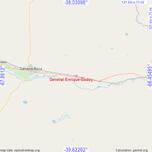
| Map corner | latitude | longitude |
|---|---|---|
| Upper-left | -38.53098°, | -67.8612° |
| Center: | -39.07891°, | -67.15807° |
| Lower-right: | -39.62262°, | -66.45495° |
| Map W x H: | 121.4×121.4 km | = 75.4×75.4mi |
| max Lat: | -21.94467° ⇑92.5% North |
| General Enrique Godoy: | -39.07891° |
| min Lat: | ⇓7.5% South -54.81084° |
| min Long | General Enrique | max Long |
| -72.88605° | -67.15807° | -53.64581° |
| W 13.2%⇐ | ⇒86.8% E |
Elevation
Elevation of General Enrique Godoy is 209 m = 686 ft, and this is 140.3 m = 460 ft below average elevation for this country.
| Max E: |
4040 m = 13255 ft | 40.4% |
| Avg. | 349.3 m = 1146 ft | |
| General Enrique Godoy | 209 m = 686 ft | |
Min E: |
-2 m = -7 ft | 59.6% |
See also: Argentina elevation on elevation.city.
Geographical zone
General Enrique Godoy is located in South temperate zone (between Tropic of Capricorn and the Antarctic Circle). Distance of this Southern Tropic circle is 1739.2 km =1080.7 mi to North.| Distance of | km | miles | from General Enrique Godoy |
|---|---|---|---|
| Equator | 4345.2 | 2700 | to North |
| Tropic Capricorn | 1739.2 | 1080.7 | to North |
| Antarctic Circle | 3056 | 1898.9 | to South |
| South Pole | 5661.9 | 3518.1 | to South |


Nearby cities:
15 places around General Enrique Godoy: (largest is in red/bold)
• Allen
58.9 km =36.6 mi,  281°
281°
• Centenario
88.6 km =55.1 mi,  288°
288°
• Cervantes
20.6 km =12.8 mi, 277°
• Chichinales
20.3 km =12.6 mi,  101°
101°
• Chimpay
88.1 km =54.7 mi, 96°
• Cinco Saltos
83.3 km =51.8 mi, 290°
• Cipolletti
73.7 km =45.8 mi, 282°
• Contraalmirante Cordero
94.7 km =58.8 mi, 294°
• General Fernández Oro
67.7 km =42.1 mi, 281°
• General Roca
37.1 km =23.1 mi, 277°
• Ingeniero Luis A. Huergo
6.9 km =4.3 mi, 276°
• Mainque
12.3 km =7.6 mi, 276°
• Neuquén
79.1 km =49.2 mi, 280°
• Plottier
93.7 km =58.2 mi, 277°
• Villa Regina
8.2 km =5.1 mi,  106°
106°
Sources, notices
• [Note1] Compared only with cities in Argentina existing in our database
• [Src1] Map data: © OpenStreetMap contributors (CC-BY-SA)
• [Src2] Other city data from geonames.org with taken over terms of usage.
• [Src3] Geographical zone / Annual Mean Temperature by Robert A. Rohde @ Wikipedia
