Chivilcoy geodata
Chivilcoy (Buenos Aires) is a seat of a second-order administrative division; located in Argentina in America/Argentina/Buenos_Aires (GMT-3) time zone. With population of 54,514 people, there are 78 cities with bigger population in this country. Compared to other cities in Argentina, 76.9% of cities are located further ↑North; 67.8% of cities are located further ←West and 79% of cities have higher elevation than Chivilcoy. Note1


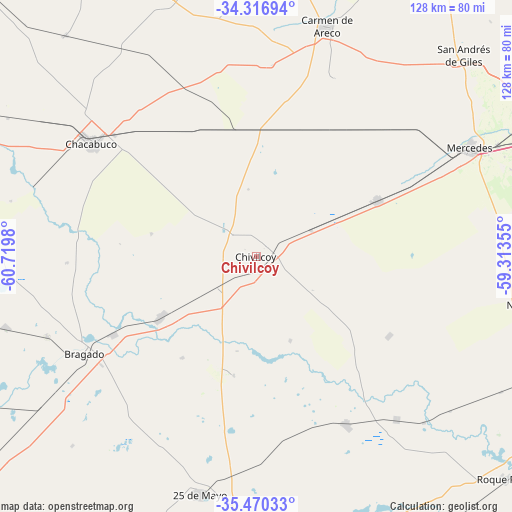
Chivilcoy GPS coordinates[2]
34° 53' 44.376" South, 60° 1' 0.012" West
| Map corner | latitude | longitude |
|---|---|---|
| Upper-left | -34.31694°, | -60.7198° |
| Center: | -34.89566°, | -60.01667° |
| Lower-right: | -35.47033°, | -59.31355° |
| Map W x H: | 128.2×128.2 km | = 79.7×79.7mi |
| max Lat: | -21.94467° ⇑76.9% North |
| Chivilcoy: | -34.89566° |
| min Lat: | ⇓23.1% South -54.81084° |
| min Long | Chivilcoy | max Long |
| -72.88605° | -60.01667° | -53.64581° |
| W 67.8%⇐ | ⇒32.2% E |
Elevation
Elevation of Chivilcoy is 60 m = 197 ft, and this is 289.3 m = 949 ft below average elevation for this country.
| Max E: |
4040 m = 13255 ft | 79% |
| Avg. | 349.3 m = 1146 ft | |
| Chivilcoy | 60 m = 197 ft | |
Min E: |
-2 m = -7 ft | 21% |
See also: Chivilcoy elevation on elevation.city.
Geographical zone
Chivilcoy is located in South temperate zone (between Tropic of Capricorn and the Antarctic Circle). Distance of this Southern Tropic circle is 1274.1 km =791.7 mi to North.| Distance of | km | miles | from Chivilcoy |
|---|---|---|---|
| Equator | 3880 | 2410.9 | to North |
| Tropic Capricorn | 1274.1 | 791.7 | to North |
| Antarctic Circle | 3521.1 | 2187.9 | to South |
| South Pole | 6127 | 3807.1 | to South |


Nearby cities:
15 places around Chivilcoy: (largest is in red/bold)
• Alberti
27.8 km =17.3 mi,  238°
238°
• Bragado
49.7 km =30.9 mi, 240°
• Capitán Sarmiento
83 km =51.6 mi,  14°
14°
• Carmen de Areco
60.3 km =37.5 mi,  17°
17°
• Chacabuco
50.4 km =31.3 mi,  304°
304°
• Lobos
89.6 km =55.7 mi,  111°
111°
• Mercedes
60 km =37.3 mi,  63°
63°
• Navarro
68.4 km =42.5 mi,  100°
100°
• Roque Pérez
83.6 km =51.9 mi,  131°
131°
• Saladillo
85.2 km =52.9 mi,  165°
165°
• Salto
70.5 km =43.8 mi,  342°
342°
• San Andrés de Giles
72.3 km =44.9 mi,  46°
46°
• San Antonio de Areco
87.4 km =54.3 mi,  34°
34°
• Suipacha
33.1 km =20.6 mi,  65°
65°
• Veinticinco de Mayo
61.3 km =38.1 mi,  193°
193°
Sources, notices
• [Note1] Compared only with cities in Argentina existing in our database
• [Src1] Map data: © OpenStreetMap contributors (CC-BY-SA)
• [Src2] Other city data from geonames.org with taken over terms of usage.
• [Src3] Geographical zone / Annual Mean Temperature by Robert A. Rohde @ Wikipedia
