Chacabuco geodata
Chacabuco (Buenos Aires) is a seat of a second-order administrative division; located in Argentina in America/Argentina/Buenos_Aires (GMT-3) time zone. With population of 34,587 people, there are 120 cities with bigger population in this country. Compared to other cities in Argentina, 73.9% of cities are located further ↑North; 64.8% of cities are located further ←West and 73.2% of cities have higher elevation than Chacabuco. Note1


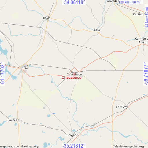
Chacabuco GPS coordinates[2]
34° 38' 30.012" South, 60° 28' 26.004" West
| Map corner | latitude | longitude |
|---|---|---|
| Upper-left | -34.06118°, | -61.17702° |
| Center: | -34.64167°, | -60.47389° |
| Lower-right: | -35.21812°, | -59.77077° |
| Map W x H: | 128.6×128.6 km | = 79.9×79.9mi |
| max Lat: | -21.94467° ⇑73.9% North |
| Chacabuco: | -34.64167° |
| min Lat: | ⇓26.1% South -54.81084° |
| min Long | Chacabuco | max Long |
| -72.88605° | -60.47389° | -53.64581° |
| W 64.8%⇐ | ⇒35.2% E |
Elevation
Elevation of Chacabuco is 73 m = 240 ft, and this is 276.3 m = 906 ft below average elevation for this country.
| Max E: |
4040 m = 13255 ft | 73.2% |
| Avg. | 349.3 m = 1146 ft | |
| Chacabuco | 73 m = 240 ft | |
Min E: |
-2 m = -7 ft | 26.8% |
See also: Argentina elevation on elevation.city.
Geographical zone
Chacabuco is located in South temperate zone (between Tropic of Capricorn and the Antarctic Circle). Distance of this Southern Tropic circle is 1245.9 km =774.2 mi to North.| Distance of | km | miles | from Chacabuco |
|---|---|---|---|
| Equator | 3851.8 | 2393.4 | to North |
| Tropic Capricorn | 1245.9 | 774.2 | to North |
| Antarctic Circle | 3549.4 | 2205.5 | to South |
| South Pole | 6155.3 | 3824.7 | to South |


Nearby cities:
15 places around Chacabuco: (largest is in red/bold)
• Alberti
46.5 km =28.9 mi,  157°
157°
• Arrecifes
72.7 km =45.2 mi,  27°
27°
• Bragado
53.1 km =33 mi,  181°
181°
• Capitán Sarmiento
81.6 km =50.7 mi,  50°
50°
• Carmen de Areco
66.4 km =41.3 mi,  63°
63°
• Chivilcoy
50.4 km =31.3 mi,  124°
124°
• General Arenales
85 km =52.8 mi,  296°
296°
• General Viamonte
64.9 km =40.3 mi,  232°
232°
• Junín
43.4 km =27 mi,  278°
278°
• Mercedes
95.4 km =59.3 mi,  90°
90°
• Pergamino
84.1 km =52.3 mi,  353°
353°
• Rojas
55.1 km =34.2 mi,  334°
334°
• Salto
43.7 km =27.2 mi, 27°
• Suipacha
73.3 km =45.5 mi,  101°
101°
• Veinticinco de Mayo
92.1 km =57.2 mi, 162°
Sources, notices
• [Note1] Compared only with cities in Argentina existing in our database
• [Src1] Map data: © OpenStreetMap contributors (CC-BY-SA)
• [Src2] Other city data from geonames.org with taken over terms of usage.
• [Src3] Geographical zone / Annual Mean Temperature by Robert A. Rohde @ Wikipedia
