Zellach geodata
Zellach (Carinthia) is a populated place; located in Austria in Europe/Vienna (GMT+2) time zone. With population of 613 people, there are 2090 cities with bigger population in this country. Compared to other cities in Austria, 89.1% of cities are located further ↑North; 52.5% of cities are located further ←West and 79.7% of cities have lower elevation than Zellach. Note1
Administrative division(s):
- Level 1: Carinthia
- Level 2: Politischer Bezirk Wolfsberg
- Level 3: Frantschach-St. Gertraud


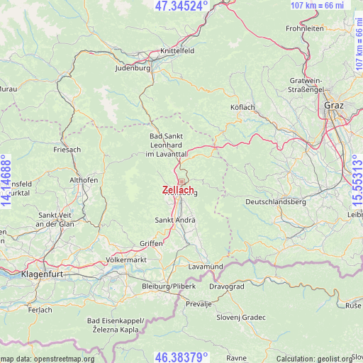
Zellach GPS coordinates[2]
46° 52' 0.012" North, 14° 51' 0" East
| Map corner | latitude | longitude |
|---|---|---|
| Upper-left | 47.34524°, | 14.14688° |
| Center: | 46.86667°, | 14.85° |
| Lower-right: | 46.38379°, | 15.55313° |
| Map W x H: | 106.9×106.9 km | = 66.4×66.4mi |
| max Lat: | 48.98333° ⇑89.1% North |
| Zellach: | 46.86667° |
| min Lat: | ⇓10.9% South 46.48841° |
| min Long | Zellach | max Long |
| 9.57802° | 14.85° | 17.1° |
| W 52.5%⇐ | ⇒47.5% E |
Elevation
Elevation of Zellach is 712 m = 2336 ft, and this is 206.5 m = 677 ft above average elevation for this country.
| Max E: |
2140 m = 7021 ft | 20.3% |
| Zellach | 712 m 2336 ft | |
| Avg. | 505.5 m = 1658 ft | |
Min E: |
118 m = 387 ft | 79.7% |
See also: Austria elevation on elevation.city.
Geographical zone
Zellach is located in North temperate zone (between Tropic of Cancer and the Arctic Circle). Distance of this North polar circle is 2190.1 km =1360.9 mi to North.| Distance of | km | miles | from Zellach |
|---|---|---|---|
| North Pole | 4796 | 2980.1 | to North |
| Arctic Circle | 2190.1 | 1360.9 | to North |
| Tropic Cancer | 2605.2 | 1618.8 | to South |
| Equator | 5211.1 | 3238 | to South |


Nearby cities:
15 places around Zellach: (largest is in red/bold)
• Auen
3.1 km =1.9 mi,  306°
306°
• Gries
3.9 km =2.4 mi,  178°
178°
• Kleinedling
6.1 km =3.8 mi,  196°
196°
• Preitenegg
10 km =6.2 mi,  35°
35°
• Priel
4.5 km =2.8 mi, 196°
• Reding
5.6 km =3.5 mi, 180°
• Ritzing
2.1 km =1.3 mi,  194°
194°
• Sankt Andrä
11.2 km =7 mi, 191°
• Sankt Jakob
3.9 km =2.4 mi, 198°
• Sankt Johann
5.7 km =3.5 mi,  167°
167°
• Sankt Margarethen im Lavanttal
4.2 km =2.6 mi,  244°
244°
• Sankt Michael
5.2 km =3.2 mi,  226°
226°
• Sankt Stefan
6.6 km =4.1 mi, 178°
• Schleifen
3.9 km =2.4 mi, 203°
• Wolfsberg
2.9 km =1.8 mi, 188°
Sources, notices
• [Note1] Compared only with cities in Austria existing in our database
• [Src1] Map data: © OpenStreetMap contributors (CC-BY-SA)
• [Src2] Other city data from geonames.org with taken over terms of usage.
• [Src3] Geographical zone / Annual Mean Temperature by Robert A. Rohde @ Wikipedia
