Preitenegg geodata
Preitenegg (Carinthia) is a seat of a third-order administrative division; located in Austria in Europe/Vienna (GMT+2) time zone. With population of 271 people, there are 2785 cities with bigger population in this country. Compared to other cities in Austria, 86.8% of cities are located further ↑North; 53.4% of cities are located further ←West and 96.1% of cities have lower elevation than Preitenegg. Note1
Administrative division(s):
- Level 1: Carinthia
- Level 2: Politischer Bezirk Wolfsberg
- Level 3: Preitenegg


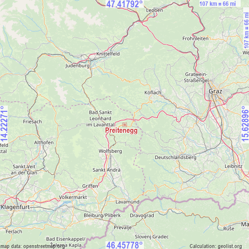
Preitenegg GPS coordinates[2]
46° 56' 24" North, 14° 55' 32.988" East
| Map corner | latitude | longitude |
|---|---|---|
| Upper-left | 47.41792°, | 14.22271° |
| Center: | 46.94°, | 14.92583° |
| Lower-right: | 46.45778°, | 15.62896° |
| Map W x H: | 106.8×106.8 km | = 66.4×66.4mi |
| max Lat: | 48.98333° ⇑86.8% North |
| Preitenegg: | 46.94° |
| min Lat: | ⇓13.2% South 46.48841° |
| min Long | Preitenegg | max Long |
| 9.57802° | 14.92583° | 17.1° |
| W 53.4%⇐ | ⇒46.6% E |
Elevation
Elevation of Preitenegg is 1069 m = 3507 ft, and this is 563.5 m = 1849 ft above average elevation for this country.
| Max E: |
2140 m = 7021 ft | 3.9% |
| Preitenegg | 1069 m 3507 ft | |
| Avg. | 505.5 m = 1658 ft | |
Min E: |
118 m = 387 ft | 96.1% |
See also: Austria elevation on elevation.city.
Geographical zone
Preitenegg is located in North temperate zone (between Tropic of Cancer and the Arctic Circle). Distance of this North polar circle is 2181.9 km =1355.8 mi to North.| Distance of | km | miles | from Preitenegg |
|---|---|---|---|
| North Pole | 4787.8 | 2975 | to North |
| Arctic Circle | 2181.9 | 1355.8 | to North |
| Tropic Cancer | 2613.3 | 1623.8 | to South |
| Equator | 5219.2 | 3243.1 | to South |


Nearby cities:
15 places around Preitenegg: (largest is in red/bold)
• Auen
10.4 km =6.5 mi,  232°
232°
• Bad Sankt Leonhard im Lavanttal
10.5 km =6.5 mi,  283°
283°
• Edelschrott
13.2 km =8.2 mi,  46°
46°
• Gries
13.3 km =8.3 mi,  205°
205°
• Hirschegg Rein
9.3 km =5.8 mi,  14°
14°
• Kliening
12.1 km =7.5 mi, 275°
• Kloster
13.5 km =8.4 mi,  117°
117°
• Modriach
9.5 km =5.9 mi,  83°
83°
• Pack
6.2 km =3.9 mi, 45°
• Ritzing
12 km =7.5 mi, 211°
• Sankt Jakob
13.8 km =8.6 mi, 210°
• Sankt Margarethen im Lavanttal
13.8 km =8.6 mi,  223°
223°
• Schleifen
13.8 km =8.6 mi, 212°
• Wolfsberg
12.7 km =7.9 mi, 209°
• Zellach
10 km =6.2 mi, 215°
Sources, notices
• [Note1] Compared only with cities in Austria existing in our database
• [Src1] Map data: © OpenStreetMap contributors (CC-BY-SA)
• [Src2] Other city data from geonames.org with taken over terms of usage.
• [Src3] Geographical zone / Annual Mean Temperature by Robert A. Rohde @ Wikipedia
