Studenzen geodata
Studenzen (Styria) is a seat of a third-order administrative division; located in Austria in Europe/Vienna (GMT+2) time zone. With population of 449 people, there are 2567 cities with bigger population in this country. Compared to other cities in Austria, 84% of cities are located further ↑North; 73.5% of cities are located further ←West and 71.9% of cities have higher elevation than Studenzen. Note1
Administrative division(s):
- Level 1: Styria
- Level 2: Politischer Bezirk Südoststeiermark
- Level 3: Kirchberg an der Raab


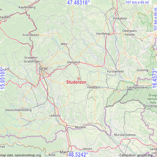
Studenzen GPS coordinates[2]
47° 0' 20.988" North, 15° 45' 15.012" East
| Map corner | latitude | longitude |
|---|---|---|
| Upper-left | 47.48316°, | 15.05105° |
| Center: | 47.00583°, | 15.75417° |
| Lower-right: | 46.5242°, | 16.4573° |
| Map W x H: | 106.6×106.6 km | = 66.2×66.2mi |
| max Lat: | 48.98333° ⇑84% North |
| Studenzen: | 47.00583° |
| min Lat: | ⇓16% South 46.48841° |
| min Long | Studenzen | max Long |
| 9.57802° | 15.75417° | 17.1° |
| W 73.5%⇐ | ⇒26.5% E |
Elevation
Elevation of Studenzen is 319 m = 1047 ft, and this is 186.5 m = 612 ft below average elevation for this country.
| Max E: |
2140 m = 7021 ft | 71.9% |
| Avg. | 505.5 m = 1658 ft | |
| Studenzen | 319 m = 1047 ft | |
Min E: |
118 m = 387 ft | 28.1% |
See also: Austria elevation on elevation.city.
Geographical zone
Studenzen is located in North temperate zone (between Tropic of Cancer and the Arctic Circle). Distance of this North polar circle is 2174.6 km =1351.2 mi to North.| Distance of | km | miles | from Studenzen |
|---|---|---|---|
| North Pole | 4780.5 | 2970.5 | to North |
| Arctic Circle | 2174.6 | 1351.2 | to North |
| Tropic Cancer | 2620.6 | 1628.4 | to South |
| Equator | 5226.6 | 3247.7 | to South |


Nearby cities:
15 places around Studenzen: (largest is in red/bold)
• Edelsbach bei Feldbach
6.5 km =4 mi,  106°
106°
• Entschendorf bei Gleisdorf
6.4 km =4 mi,  320°
320°
• Fladnitz im Raabtal
2.8 km =1.7 mi,  123°
123°
• Kirchberg an der Raab
2.4 km =1.5 mi,  156°
156°
• Mitterfladnitz
3.7 km =2.3 mi,  81°
81°
• Oberdorf am Hochegg
3.9 km =2.4 mi,  219°
219°
• Oberstorcha
5.6 km =3.5 mi,  141°
141°
• Petersdorf II
5.6 km =3.5 mi,  259°
259°
• Sankt Marein bei Graz
5.4 km =3.4 mi,  281°
281°
• Sankt Marein bei Graz-Markt
5.2 km =3.2 mi, 282°
• Sankt Marein bei Graz-Umgebung
4.6 km =2.9 mi,  293°
293°
• Sankt Margarethen an der Raab
4.9 km =3 mi,  356°
356°
• Sulz bei Gleisdorf
6.9 km =4.3 mi,  346°
346°
• Takern Zwei
3.2 km =2 mi,  17°
17°
• Wörth bei Kirchberg an der Raab
4.5 km =2.8 mi,  167°
167°
Sources, notices
• [Note1] Compared only with cities in Austria existing in our database
• [Src1] Map data: © OpenStreetMap contributors (CC-BY-SA)
• [Src2] Other city data from geonames.org with taken over terms of usage.
• [Src3] Geographical zone / Annual Mean Temperature by Robert A. Rohde @ Wikipedia
