Selpritsch geodata
Selpritsch (Carinthia) is a populated place; located in Austria in Europe/Vienna (GMT+2) time zone. With population of 789 people, there are 1638 cities with bigger population in this country. Compared to other cities in Austria, 98.7% of cities are located further ↑North; 64.3% of cities are located further →East and 55.7% of cities have lower elevation than Selpritsch. Note1
Administrative division(s):
- Level 1: Carinthia
- Level 2: Politischer Bezirk Villach Land
- Level 3: Velden am Wörther See


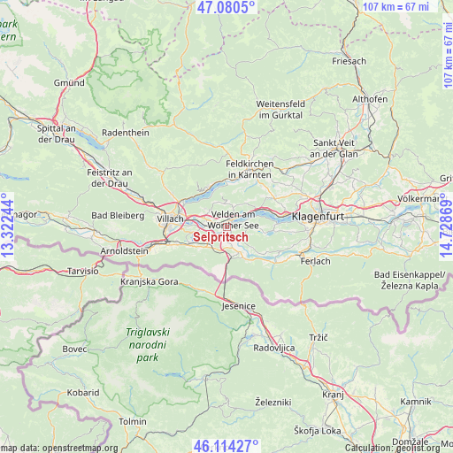
Selpritsch GPS coordinates[2]
46° 35' 58.344" North, 14° 1' 32.016" East
| Map corner | latitude | longitude |
|---|---|---|
| Upper-left | 47.0805°, | 13.32244° |
| Center: | 46.59954°, | 14.02556° |
| Lower-right: | 46.11427°, | 14.72869° |
| Map W x H: | 107.4×107.4 km | = 66.7×66.7mi |
| max Lat: | 48.98333° ⇑98.7% North |
| Selpritsch: | 46.59954° |
| min Lat: | ⇓1.3% South 46.48841° |
| min Long | Selpritsch | max Long |
| 9.57802° | 14.02556° | 17.1° |
| W 35.7%⇐ | ⇒64.3% E |
Elevation
Elevation of Selpritsch is 490 m = 1608 ft, and this is 15.5 m = 51 ft below average elevation for this country.
| Max E: |
2140 m = 7021 ft | 44.3% |
| Avg. | 505.5 m = 1658 ft | |
| Selpritsch | 490 m = 1608 ft | |
Min E: |
118 m = 387 ft | 55.7% |
See also: Austria elevation on elevation.city.
Geographical zone
Selpritsch is located in North temperate zone (between Tropic of Cancer and the Arctic Circle). Distance of this North polar circle is 2219.8 km =1379.3 mi to North.| Distance of | km | miles | from Selpritsch |
|---|---|---|---|
| North Pole | 4825.7 | 2998.6 | to North |
| Arctic Circle | 2219.8 | 1379.3 | to North |
| Tropic Cancer | 2575.5 | 1600.3 | to South |
| Equator | 5181.4 | 3219.6 | to South |


Nearby cities:
15 places around Selpritsch: (largest is in red/bold)
• Finkenstein am Faaker See
7.3 km =4.5 mi,  251°
251°
• Föderlach I
4.9 km =3 mi,  270°
270°
• Kaltschach
6.1 km =3.8 mi,  288°
288°
• Latschach ober dem Faakersee
8.8 km =5.5 mi,  236°
236°
• Ledenitzen
6.1 km =3.8 mi,  233°
233°
• Lind ob Velden
1.8 km =1.1 mi,  279°
279°
• Maria Elend
8.8 km =5.5 mi,  148°
148°
• Rosegg
1.4 km =0.9 mi,  207°
207°
• Sankt Jakob
6.2 km =3.9 mi,  157°
157°
• Sankt Ulrich
8.4 km =5.2 mi, 277°
• Schiefling am See
5.5 km =3.4 mi,  84°
84°
• Schleben
7.4 km =4.6 mi, 288°
• Velden am Wörthersee
1.9 km =1.2 mi,  38°
38°
• Wernberg
7.3 km =4.5 mi, 285°
• Wudmath
3.4 km =2.1 mi,  264°
264°
Sources, notices
• [Note1] Compared only with cities in Austria existing in our database
• [Src1] Map data: © OpenStreetMap contributors (CC-BY-SA)
• [Src2] Other city data from geonames.org with taken over terms of usage.
• [Src3] Geographical zone / Annual Mean Temperature by Robert A. Rohde @ Wikipedia
