Röthis geodata
Röthis (Vorarlberg) is a seat of a third-order administrative division; located in Austria in Europe/Vienna (GMT+2) time zone. With population of 1,942 people, there are 634 cities with bigger population in this country. Compared to other cities in Austria, 65.9% of cities are located further ↑North; 99.4% of cities are located further →East and 57.5% of cities have lower elevation than Röthis. Note1
Administrative division(s):
- Level 1: Vorarlberg
- Level 2: Politischer Bezirk Feldkirch
- Level 3: Röthis


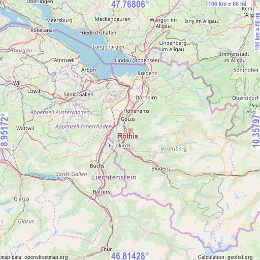
Röthis GPS coordinates[2]
47° 17' 35.952" North, 9° 39' 17.424" East
| Map corner | latitude | longitude |
|---|---|---|
| Upper-left | 47.76806°, | 8.95172° |
| Center: | 47.29332°, | 9.65484° |
| Lower-right: | 46.81428°, | 10.35797° |
| Map W x H: | 106.1×10⁶ km | = 65.9×65.9mi |
| max Lat: | 48.98333° ⇑65.9% North |
| Röthis: | 47.29332° |
| min Lat: | ⇓34.1% South 46.48841° |
| min Long | Röthis | max Long |
| 9.57802° | 9.65484° | 17.1° |
| W 0.6%⇐ | ⇒99.4% E |
Elevation
Elevation of Röthis is 501 m = 1644 ft, and this is 4.5 m = 15 ft below average elevation for this country.
| Max E: |
2140 m = 7021 ft | 42.5% |
| Avg. | 505.5 m = 1658 ft | |
| Röthis | 501 m = 1644 ft | |
Min E: |
118 m = 387 ft | 57.5% |
See also: Austria elevation on elevation.city.
Geographical zone
Röthis is located in North temperate zone (between Tropic of Cancer and the Arctic Circle). Distance of this North polar circle is 2142.6 km =1331.3 mi to North.| Distance of | km | miles | from Röthis |
|---|---|---|---|
| North Pole | 4748.5 | 2950.6 | to North |
| Arctic Circle | 2142.6 | 1331.3 | to North |
| Tropic Cancer | 2652.6 | 1648.2 | to South |
| Equator | 5258.5 | 3267.5 | to South |


Nearby cities:
15 places around Röthis: (largest is in red/bold)
• Altach
6.3 km =3.9 mi,  356°
356°
• Batschuns
1.2 km =0.7 mi,  197°
197°
• Fraxern
2.8 km =1.7 mi,  30°
30°
• Göfis
6.8 km =4.2 mi,  192°
192°
• Götzis
4.7 km =2.9 mi,  339°
339°
• Klaus
1.9 km =1.2 mi, 340°
• Koblach
6.1 km =3.8 mi,  316°
316°
• Meiningen
5.8 km =3.6 mi,  276°
276°
• Muntlix
1.2 km =0.7 mi,  163°
163°
• Rankweil
2.6 km =1.6 mi, 199°
• Sulz
0.7 km =0.4 mi, 198°
• Tal
4.5 km =2.8 mi,  131°
131°
• Viktorsberg
1.7 km =1.1 mi,  60°
60°
• Weiler
0.8 km =0.5 mi,  332°
332°
• Übersaxen
4.7 km =2.9 mi,  165°
165°
Sources, notices
• [Note1] Compared only with cities in Austria existing in our database
• [Src1] Map data: © OpenStreetMap contributors (CC-BY-SA)
• [Src2] Other city data from geonames.org with taken over terms of usage.
• [Src3] Geographical zone / Annual Mean Temperature by Robert A. Rohde @ Wikipedia
