Raggal geodata
Raggal (Vorarlberg) is a seat of a third-order administrative division; located in Austria in Europe/Vienna (GMT+2) time zone. With population of 673 people, there are 1921 cities with bigger population in this country. Compared to other cities in Austria, 71.7% of cities are located further ↑North; 98% of cities are located further →East and 94.7% of cities have lower elevation than Raggal. Note1


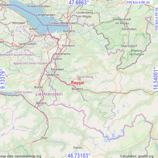
Raggal GPS coordinates[2]
47° 12' 38.952" North, 9° 50' 12.768" East
| Map corner | latitude | longitude |
|---|---|---|
| Upper-left | 47.6863°, | 9.13376° |
| Center: | 47.21082°, | 9.83688° |
| Lower-right: | 46.73103°, | 10.54001° |
| Map W x H: | 106.2×106.2 km | = 66×66mi |
| max Lat: | 48.98333° ⇑71.7% North |
| Raggal: | 47.21082° |
| min Lat: | ⇓28.3% South 46.48841° |
| min Long | Raggal | max Long |
| 9.57802° | 9.83688° | 17.1° |
| W 2%⇐ | ⇒98% E |
Elevation
Elevation of Raggal is 1011 m = 3317 ft, and this is 505.5 m = 1658 ft above average elevation for this country.
| Max E: |
2140 m = 7021 ft | 5.3% |
| Raggal | 1011 m 3317 ft | |
| Avg. | 505.5 m = 1658 ft | |
Min E: |
118 m = 387 ft | 94.7% |
See also: Austria elevation on elevation.city.
Geographical zone
Raggal is located in North temperate zone (between Tropic of Cancer and the Arctic Circle). Distance of this North polar circle is 2151.8 km =1337.1 mi to North.| Distance of | km | miles | from Raggal |
|---|---|---|---|
| North Pole | 4757.7 | 2956.3 | to North |
| Arctic Circle | 2151.8 | 1337.1 | to North |
| Tropic Cancer | 2643.4 | 1642.5 | to South |
| Equator | 5249.4 | 3261.8 | to South |


Nearby cities:
15 places around Raggal: (largest is in red/bold)
• Ausserbraz
8.4 km =5.2 mi,  145°
145°
• Blons
1.4 km =0.9 mi,  351°
351°
• Bludenz
6.3 km =3.9 mi,  189°
189°
• Bludesch
7.9 km =4.9 mi,  261°
261°
• Bürs
7.3 km =4.5 mi,  202°
202°
• Bürserberg
8.5 km =5.3 mi,  212°
212°
• Dünserberg
8.7 km =5.4 mi,  282°
282°
• Lorüns
8.7 km =5.4 mi,  173°
173°
• Ludesch
4.2 km =2.6 mi,  253°
253°
• Nüziders
5.6 km =3.5 mi, 209°
• Schnifis
7.9 km =4.9 mi,  274°
274°
• Sonntag
5.5 km =3.4 mi,  56°
56°
• Stallehr
8.7 km =5.4 mi, 173°
• Thüringen
5.4 km =3.4 mi, 257°
• Thüringerberg
3.9 km =2.4 mi, 275°
Sources, notices
• [Note1] Compared only with cities in Austria existing in our database
• [Src1] Map data: © OpenStreetMap contributors (CC-BY-SA)
• [Src2] Other city data from geonames.org with taken over terms of usage.
• [Src3] Geographical zone / Annual Mean Temperature by Robert A. Rohde @ Wikipedia
