Sonntag geodata
Sonntag (Vorarlberg) is a seat of a third-order administrative division; located in Austria in Europe/Vienna (GMT+2) time zone. In our database, there are 2958 cities with bigger population. Compared to other cities in Austria, 69.9% of cities are located further ↑North; 97.6% of cities are located further →East and 90.5% of cities have lower elevation than Sonntag. Note1
Administrative division(s):
- Level 1: Vorarlberg
- Level 2: Politischer Bezirk Bludenz
- Level 3: Sonntag


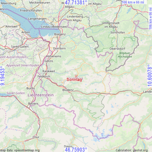
Sonntag GPS coordinates[2]
47° 14' 18.852" North, 9° 53' 51.54" East
| Map corner | latitude | longitude |
|---|---|---|
| Upper-left | 47.71381°, | 9.19453° |
| Center: | 47.23857°, | 9.89765° |
| Lower-right: | 46.75903°, | 10.60078° |
| Map W x H: | 106.2×106.2 km | = 66×66mi |
| max Lat: | 48.98333° ⇑69.9% North |
| Sonntag: | 47.23857° |
| min Lat: | ⇓30.1% South 46.48841° |
| min Long | Sonntag | max Long |
| 9.57802° | 9.89765° | 17.1° |
| W 2.4%⇐ | ⇒97.6% E |
Elevation
Elevation of Sonntag is 891 m = 2923 ft, and this is 385.5 m = 1265 ft above average elevation for this country.
| Max E: |
2140 m = 7021 ft | 9.5% |
| Sonntag | 891 m 2923 ft | |
| Avg. | 505.5 m = 1658 ft | |
Min E: |
118 m = 387 ft | 90.5% |
See also: Austria elevation on elevation.city.
Geographical zone
Sonntag is located in North temperate zone (between Tropic of Cancer and the Arctic Circle). Distance of this North polar circle is 2148.7 km =1335.1 mi to North.| Distance of | km | miles | from Sonntag |
|---|---|---|---|
| North Pole | 4754.6 | 2954.4 | to North |
| Arctic Circle | 2148.7 | 1335.1 | to North |
| Tropic Cancer | 2646.5 | 1644.5 | to South |
| Equator | 5252.4 | 3263.7 | to South |


Nearby cities:
15 places around Sonntag: (largest is in red/bold)
• Au
11.2 km =7 mi,  34°
34°
• Ausserbraz
10 km =6.2 mi,  178°
178°
• Blons
5.1 km =3.2 mi,  250°
250°
• Bludenz
10.9 km =6.8 mi,  211°
211°
• Damüls
4.7 km =2.9 mi,  354°
354°
• Innerbraz
10 km =6.2 mi,  171°
171°
• Lorüns
12.3 km =7.6 mi,  197°
197°
• Ludesch
9.7 km =6 mi,  243°
243°
• Nüziders
10.9 km =6.8 mi,  222°
222°
• Raggal
5.5 km =3.4 mi, 236°
• Rehmen
12 km =7.5 mi,  39°
39°
• Schoppernau
12.1 km =7.5 mi,  47°
47°
• Stallehr
12.3 km =7.6 mi, 197°
• Thüringen
10.8 km =6.7 mi, 246°
• Thüringerberg
8.9 km =5.5 mi, 252°
Sources, notices
• [Note1] Compared only with cities in Austria existing in our database
• [Src1] Map data: © OpenStreetMap contributors (CC-BY-SA)
• [Src2] Other city data from geonames.org with taken over terms of usage.
• [Src3] Geographical zone / Annual Mean Temperature by Robert A. Rohde @ Wikipedia
