Nenzing geodata
Nenzing (Vorarlberg) is a seat of a third-order administrative division; located in Austria in Europe/Vienna (GMT+2) time zone. With population of 4,357 people, there are 228 cities with bigger population in this country. Compared to other cities in Austria, 73.5% of cities are located further ↑North; 99% of cities are located further →East and 61.4% of cities have lower elevation than Nenzing. Note1
Administrative division(s):
- Level 1: Vorarlberg
- Level 2: Politischer Bezirk Bludenz
- Level 3: Nenzing


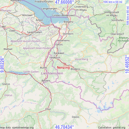
Nenzing GPS coordinates[2]
47° 11' 3.696" North, 9° 42' 19.404" East
| Map corner | latitude | longitude |
|---|---|---|
| Upper-left | 47.66008°, | 9.00226° |
| Center: | 47.18436°, | 9.70539° |
| Lower-right: | 46.70434°, | 10.40852° |
| Map W x H: | 106.3×106.3 km | = 66.1×66.1mi |
| max Lat: | 48.98333° ⇑73.5% North |
| Nenzing: | 47.18436° |
| min Lat: | ⇓26.5% South 46.48841° |
| min Long | Nenzing | max Long |
| 9.57802° | 9.70539° | 17.1° |
| W 1%⇐ | ⇒99% E |
Elevation
Elevation of Nenzing is 527 m = 1729 ft, and this is 21.5 m = 71 ft above average elevation for this country.
| Max E: |
2140 m = 7021 ft | 38.6% |
| Nenzing | 527 m 1729 ft | |
| Avg. | 505.5 m = 1658 ft | |
Min E: |
118 m = 387 ft | 61.4% |
See also: Austria elevation on elevation.city.
Geographical zone
Nenzing is located in North temperate zone (between Tropic of Cancer and the Arctic Circle). Distance of this North polar circle is 2154.8 km =1338.9 mi to North.| Distance of | km | miles | from Nenzing |
|---|---|---|---|
| North Pole | 4760.7 | 2958.2 | to North |
| Arctic Circle | 2154.8 | 1338.9 | to North |
| Tropic Cancer | 2640.5 | 1640.7 | to South |
| Equator | 5246.4 | 3260 | to South |


Nearby cities:
15 places around Nenzing: (largest is in red/bold)
• Beschling
2 km =1.2 mi,  295°
295°
• Bludesch
2.7 km =1.7 mi,  50°
50°
• Bürserberg
6.9 km =4.3 mi,  127°
127°
• Düns
4.4 km =2.7 mi,  11°
11°
• Dünserberg
5 km =3.1 mi,  16°
16°
• Frastanz
6.8 km =4.2 mi, 302°
• Ludesch
6.1 km =3.8 mi,  73°
73°
• Mittelberg
5.3 km =3.3 mi, 296°
• Nüziders
7.4 km =4.6 mi,  105°
105°
• Röns
3.6 km =2.2 mi,  353°
353°
• Satteins
4.6 km =2.9 mi,  320°
320°
• Schlins
1.8 km =1.1 mi, 346°
• Schnifis
4.2 km =2.6 mi,  30°
30°
• Thüringen
4.9 km =3 mi, 69°
• Thüringerberg
6.9 km =4.3 mi,  60°
60°
Sources, notices
• [Note1] Compared only with cities in Austria existing in our database
• [Src1] Map data: © OpenStreetMap contributors (CC-BY-SA)
• [Src2] Other city data from geonames.org with taken over terms of usage.
• [Src3] Geographical zone / Annual Mean Temperature by Robert A. Rohde @ Wikipedia
