Moosburg geodata
Moosburg (Carinthia) is a seat of a third-order administrative division; located in Austria in Europe/Vienna (GMT+2) time zone. With population of 1,030 people, there are 1244 cities with bigger population in this country. Compared to other cities in Austria, 96.6% of cities are located further ↑North; 61.2% of cities are located further →East and 57.3% of cities have lower elevation than Moosburg. Note1
Administrative division(s):
- Level 1: Carinthia
- Level 2: Politischer Bezirk Klagenfurt Land
- Level 3: Moosburg


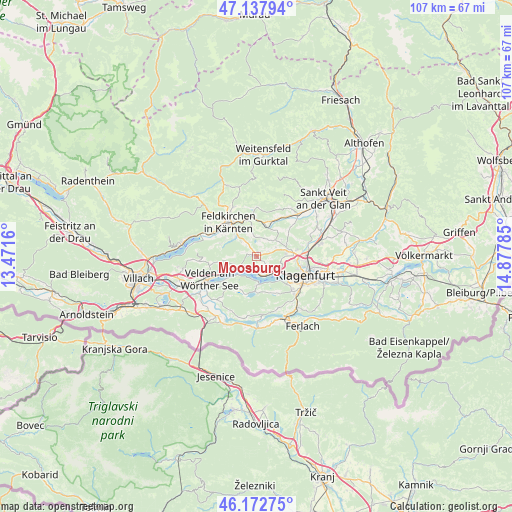
Moosburg GPS coordinates[2]
46° 39' 27" North, 14° 10' 28.992" East
| Map corner | latitude | longitude |
|---|---|---|
| Upper-left | 47.13794°, | 13.4716° |
| Center: | 46.6575°, | 14.17472° |
| Lower-right: | 46.17275°, | 14.87785° |
| Map W x H: | 107.3×107.3 km | = 66.7×66.7mi |
| max Lat: | 48.98333° ⇑96.6% North |
| Moosburg: | 46.6575° |
| min Lat: | ⇓3.4% South 46.48841° |
| min Long | Moosburg | max Long |
| 9.57802° | 14.17472° | 17.1° |
| W 38.8%⇐ | ⇒61.2% E |
Elevation
Elevation of Moosburg is 500 m = 1640 ft, and this is 5.5 m = 18 ft below average elevation for this country.
| Max E: |
2140 m = 7021 ft | 42.7% |
| Avg. | 505.5 m = 1658 ft | |
| Moosburg | 500 m = 1640 ft | |
Min E: |
118 m = 387 ft | 57.3% |
See also: Austria elevation on elevation.city.
Geographical zone
Moosburg is located in North temperate zone (between Tropic of Cancer and the Arctic Circle). Distance of this North polar circle is 2213.3 km =1375.3 mi to North.| Distance of | km | miles | from Moosburg |
|---|---|---|---|
| North Pole | 4819.2 | 2994.5 | to North |
| Arctic Circle | 2213.3 | 1375.3 | to North |
| Tropic Cancer | 2581.9 | 1604.3 | to South |
| Equator | 5187.8 | 3223.5 | to South |


Nearby cities:
15 places around Moosburg: (largest is in red/bold)
• Feldkirchen in Kärnten
9.5 km =5.9 mi,  320°
320°
• Glanegg
7.5 km =4.7 mi,  14°
14°
• Keutschach am See
7.2 km =4.5 mi,  171°
171°
• Krumpendorf
4.2 km =2.6 mi,  130°
130°
• Lindl
8.9 km =5.5 mi, 316°
• Maria Wörth
4.7 km =2.9 mi,  191°
191°
• Markstein
6.3 km =3.9 mi,  312°
312°
• Mautbrücken
7.1 km =4.4 mi, 11°
• Pörtschach am Wörthersee
3.2 km =2 mi,  222°
222°
• Reifnitz
5.6 km =3.5 mi, 174°
• Sankt Martin
9.5 km =5.9 mi,  118°
118°
• Sankt Peter
1.2 km =0.7 mi,  32°
32°
• Schiefling am See
8.3 km =5.2 mi, 224°
• Villacher Vorstadt
9.5 km =5.9 mi,  113°
113°
• Wölfnitz
6.4 km =4 mi,  81°
81°
Sources, notices
• [Note1] Compared only with cities in Austria existing in our database
• [Src1] Map data: © OpenStreetMap contributors (CC-BY-SA)
• [Src2] Other city data from geonames.org with taken over terms of usage.
• [Src3] Geographical zone / Annual Mean Temperature by Robert A. Rohde @ Wikipedia
