Mistelbach geodata
Mistelbach (Lower Austria) is a seat of a third-order administrative division; located in Austria in Europe/Vienna (GMT+2) time zone. With population of 6,463 people, there are 150 cities with bigger population in this country. Compared to other cities in Austria, 95.9% of cities are located further ↓South; 95.4% of cities are located further ←West and 88.2% of cities have higher elevation than Mistelbach. Note1
Administrative division(s):
- Level 1: Lower Austria
- Level 2: Politischer Bezirk Mistelbach
- Level 3: Mistelbach


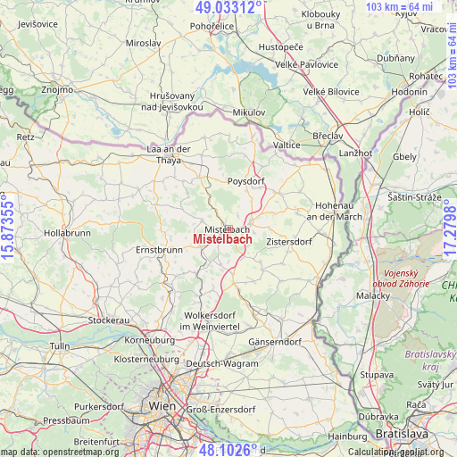
Mistelbach GPS coordinates[2]
48° 34' 12" North, 16° 34' 36.012" East
| Map corner | latitude | longitude |
|---|---|---|
| Upper-left | 49.03312°, | 15.87355° |
| Center: | 48.57°, | 16.57667° |
| Lower-right: | 48.1026°, | 17.2798° |
| Map W x H: | 103.5×103.5 km | = 64.3×64.3mi |
| max Lat: | 48.98333° ⇑4.1% North |
| Mistelbach: | 48.57° |
| min Lat: | ⇓95.9% South 46.48841° |
| min Long | Mistelbach | max Long |
| 9.57802° | 16.57667° | 17.1° |
| W 95.4%⇐ | ⇒4.6% E |
Elevation
Elevation of Mistelbach is 228 m = 748 ft, and this is 277.5 m = 910 ft below average elevation for this country.
| Max E: |
2140 m = 7021 ft | 88.2% |
| Avg. | 505.5 m = 1658 ft | |
| Mistelbach | 228 m = 748 ft | |
Min E: |
118 m = 387 ft | 11.8% |
See also: Austria elevation on elevation.city.
Geographical zone
Mistelbach is located in North temperate zone (between Tropic of Cancer and the Arctic Circle). Distance of this North polar circle is 2000.7 km =1243.2 mi to North.| Distance of | km | miles | from Mistelbach |
|---|---|---|---|
| North Pole | 4606.6 | 2862.4 | to North |
| Arctic Circle | 2000.7 | 1243.2 | to North |
| Tropic Cancer | 2794.6 | 1736.5 | to South |
| Equator | 5400.5 | 3355.7 | to South |


Nearby cities:
15 places around Mistelbach: (largest is in red/bold)
• Asparn an der Zaya
5.8 km =3.6 mi,  284°
284°
• Bullendorf
6.8 km =4.2 mi,  77°
77°
• Ebendorf
2.3 km =1.4 mi,  167°
167°
• Eibesthal
2.3 km =1.4 mi,  49°
49°
• Gaweinstal
10 km =6.2 mi,  175°
175°
• Hüttendorf
3.9 km =2.4 mi,  235°
235°
• Kettlasbrunn
5.8 km =3.6 mi,  112°
112°
• Ladendorf
8 km =5 mi, 239°
• Lanzendorf
0.8 km =0.5 mi, 243°
• Lanzendorf
1.4 km =0.9 mi, 184°
• Obersulz
10.2 km =6.3 mi,  139°
139°
• Paasdorf
5.2 km =3.2 mi,  218°
218°
• Schrick
8.3 km =5.2 mi,  159°
159°
• Siebenhirten
4.6 km =2.9 mi,  316°
316°
• Wilfersdorf
4.4 km =2.7 mi,  70°
70°
Sources, notices
• [Note1] Compared only with cities in Austria existing in our database
• [Src1] Map data: © OpenStreetMap contributors (CC-BY-SA)
• [Src2] Other city data from geonames.org with taken over terms of usage.
• [Src3] Geographical zone / Annual Mean Temperature by Robert A. Rohde @ Wikipedia
