Gaweinstal geodata
Gaweinstal (Lower Austria) is a seat of a third-order administrative division; located in Austria in Europe/Vienna (GMT+2) time zone. With population of 1,660 people, there are 754 cities with bigger population in this country. Compared to other cities in Austria, 93.8% of cities are located further ↓South; 95.7% of cities are located further ←West and 91% of cities have higher elevation than Gaweinstal. Note1
Administrative division(s):
- Level 1: Lower Austria
- Level 2: Politischer Bezirk Mistelbach
- Level 3: Gaweinstal


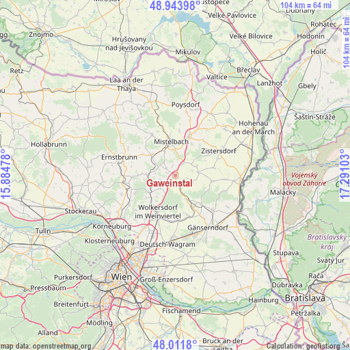
Gaweinstal GPS coordinates[2]
48° 28' 48.108" North, 16° 35' 16.44" East
| Map corner | latitude | longitude |
|---|---|---|
| Upper-left | 48.94398°, | 15.88478° |
| Center: | 48.48003°, | 16.5879° |
| Lower-right: | 48.0118°, | 17.29103° |
| Map W x H: | 103.6×103.6 km | = 64.4×64.4mi |
| max Lat: | 48.98333° ⇑6.2% North |
| Gaweinstal: | 48.48003° |
| min Lat: | ⇓93.8% South 46.48841° |
| min Long | Gaweinstal | max Long |
| 9.57802° | 16.5879° | 17.1° |
| W 95.7%⇐ | ⇒4.3% E |
Elevation
Elevation of Gaweinstal is 207 m = 679 ft, and this is 298.5 m = 979 ft below average elevation for this country.
| Max E: |
2140 m = 7021 ft | 91% |
| Avg. | 505.5 m = 1658 ft | |
| Gaweinstal | 207 m = 679 ft | |
Min E: |
118 m = 387 ft | 9% |
See also: Austria elevation on elevation.city.
Geographical zone
Gaweinstal is located in North temperate zone (between Tropic of Cancer and the Arctic Circle). Distance of this North polar circle is 2010.7 km =1249.4 mi to North.| Distance of | km | miles | from Gaweinstal |
|---|---|---|---|
| North Pole | 4616.6 | 2868.6 | to North |
| Arctic Circle | 2010.7 | 1249.4 | to North |
| Tropic Cancer | 2784.6 | 1730.3 | to South |
| Equator | 5390.5 | 3349.5 | to South |


Nearby cities:
15 places around Gaweinstal: (largest is in red/bold)
• Bad Pirawarth
3.2 km =2 mi,  166°
166°
• Ebendorf
7.8 km =4.8 mi,  357°
357°
• Groß-Schweinbarth
8 km =5 mi,  155°
155°
• Hochleithen
5.2 km =3.2 mi,  234°
234°
• Hohenruppersdorf
5.1 km =3.2 mi,  110°
110°
• Hüttendorf
8.8 km =5.5 mi,  332°
332°
• Kettlasbrunn
9 km =5.6 mi,  30°
30°
• Kreuzstetten
8.5 km =5.3 mi,  270°
270°
• Lanzendorf
8.7 km =5.4 mi,  353°
353°
• Niederkreuzstetten
8.1 km =5 mi, 267°
• Obersulz
6.2 km =3.9 mi,  69°
69°
• Paasdorf
7.2 km =4.5 mi, 325°
• Schrick
3.1 km =1.9 mi,  43°
43°
• Unterolberndorf
9.3 km =5.8 mi,  236°
236°
• Wolfpassing an der Hochleithen
6.2 km =3.9 mi, 237°
Sources, notices
• [Note1] Compared only with cities in Austria existing in our database
• [Src1] Map data: © OpenStreetMap contributors (CC-BY-SA)
• [Src2] Other city data from geonames.org with taken over terms of usage.
• [Src3] Geographical zone / Annual Mean Temperature by Robert A. Rohde @ Wikipedia
