Medraz geodata
Medraz (Tyrol) is a populated place; located in Austria in Europe/Vienna (GMT+2) time zone. With population of 1,340 people, there are 942 cities with bigger population in this country. Compared to other cities in Austria, 76.4% of cities are located further ↑North; 92.6% of cities are located further →East and 91.9% of cities have lower elevation than Medraz. Note1
Administrative division(s):
- Level 1: Tyrol
- Level 2: Politischer Bezirk Innsbruck Land
- Level 3: Fulpmes


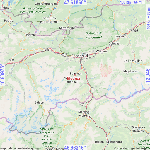
Medraz GPS coordinates[2]
47° 8' 33.216" North, 11° 20' 34.332" East
| Map corner | latitude | longitude |
|---|---|---|
| Upper-left | 47.61866°, | 10.63975° |
| Center: | 47.14256°, | 11.34287° |
| Lower-right: | 46.66216°, | 12.046° |
| Map W x H: | 106.4×106.4 km | = 66.1×66.1mi |
| max Lat: | 48.98333° ⇑76.4% North |
| Medraz: | 47.14256° |
| min Lat: | ⇓23.6% South 46.48841° |
| min Long | Medraz | max Long |
| 9.57802° | 11.34287° | 17.1° |
| W 7.4%⇐ | ⇒92.6% E |
Elevation
Elevation of Medraz is 920 m = 3018 ft, and this is 414.5 m = 1360 ft above average elevation for this country.
| Max E: |
2140 m = 7021 ft | 8.1% |
| Medraz | 920 m 3018 ft | |
| Avg. | 505.5 m = 1658 ft | |
Min E: |
118 m = 387 ft | 91.9% |
See also: Austria elevation on elevation.city.
Geographical zone
Medraz is located in North temperate zone (between Tropic of Cancer and the Arctic Circle). Distance of this North polar circle is 2159.4 km =1341.8 mi to North.| Distance of | km | miles | from Medraz |
|---|---|---|---|
| North Pole | 4765.3 | 2961 | to North |
| Arctic Circle | 2159.4 | 1341.8 | to North |
| Tropic Cancer | 2635.8 | 1637.8 | to South |
| Equator | 5241.8 | 3257.1 | to South |


Nearby cities:
15 places around Medraz: (largest is in red/bold)
• Ellbögen
8.5 km =5.3 mi,  71°
71°
• Fulpmes
1.2 km =0.7 mi,  24°
24°
• Matrei am Brenner
8.4 km =5.2 mi,  101°
101°
• Mieders
4.1 km =2.5 mi,  48°
48°
• Mutters
10.5 km =6.5 mi, 16°
• Mühlbachl
8.2 km =5.1 mi, 97°
• Natters
10.4 km =6.5 mi,  12°
12°
• Neustift im Stubaital
3.5 km =2.2 mi,  214°
214°
• Patsch
8.9 km =5.5 mi,  38°
38°
• Pfons
8.9 km =5.5 mi,  90°
90°
• Schöfens
8.9 km =5.5 mi, 95°
• Schönberg im Stubaital
7.2 km =4.5 mi, 50°
• Statz
8.6 km =5.3 mi,  109°
109°
• Telfes im Stubai
3.2 km =2 mi,  33°
33°
• Trins
8.6 km =5.3 mi,  139°
139°
Sources, notices
• [Note1] Compared only with cities in Austria existing in our database
• [Src1] Map data: © OpenStreetMap contributors (CC-BY-SA)
• [Src2] Other city data from geonames.org with taken over terms of usage.
• [Src3] Geographical zone / Annual Mean Temperature by Robert A. Rohde @ Wikipedia
