Ellbögen geodata
Ellbögen (Tyrol) is a seat of a third-order administrative division; located in Austria in Europe/Vienna (GMT+2) time zone. With population of 1,109 people, there are 1149 cities with bigger population in this country. Compared to other cities in Austria, 75% of cities are located further ↑North; 91.9% of cities are located further →East and 97.1% of cities have lower elevation than Ellbögen. Note1
Administrative division(s):
- Level 1: Tyrol
- Level 2: Politischer Bezirk Innsbruck Land
- Level 3: Ellbögen


Ellbögen GPS coordinates[2]
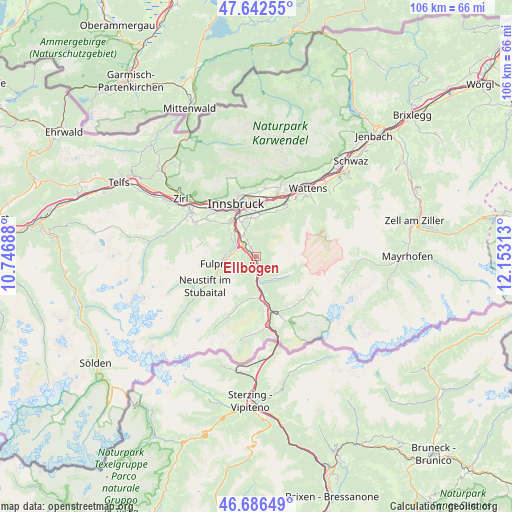
47° 10' 0.012" North, 11° 27' 0" East
| Map corner | latitude | longitude |
|---|---|---|
| Upper-left | 47.64255°, | 10.74688° |
| Center: | 47.16667°, | 11.45° |
| Lower-right: | 46.68649°, | 12.15313° |
| Map W x H: | 106.3×106.3 km | = 66.1×66.1mi |
| max Lat: | 48.98333° ⇑75% North |
| Ellbögen: | 47.16667° |
| min Lat: | ⇓25% South 46.48841° |
| min Long | Ellbögen | max Long |
| 9.57802° | 11.45° | 17.1° |
| W 8.1%⇐ | ⇒91.9% E |
Elevation
Elevation of Ellbögen is 1132 m = 3714 ft, and this is 626.5 m = 2055 ft above average elevation for this country.
| Max E: |
2140 m = 7021 ft | 2.9% |
| Ellbögen | 1132 m 3714 ft | |
| Avg. | 505.5 m = 1658 ft | |
Min E: |
118 m = 387 ft | 97.1% |
See also: Austria elevation on elevation.city.
Geographical zone
Ellbögen is located in North temperate zone (between Tropic of Cancer and the Arctic Circle). Distance of this North polar circle is 2156.7 km =1340.1 mi to North.| Distance of | km | miles | from Ellbögen |
|---|---|---|---|
| North Pole | 4762.6 | 2959.3 | to North |
| Arctic Circle | 2156.7 | 1340.1 | to North |
| Tropic Cancer | 2638.5 | 1639.5 | to South |
| Equator | 5244.4 | 3258.7 | to South |


Nearby cities:
15 places around Ellbögen: (largest is in red/bold)
• Ausserweg
4.5 km =2.8 mi,  145°
145°
• Fulpmes
7.8 km =4.8 mi,  257°
257°
• Igls
7.8 km =4.8 mi,  337°
337°
• Matrei am Brenner
4.3 km =2.7 mi,  178°
178°
• Mauern
7.5 km =4.7 mi,  170°
170°
• Mieders
5 km =3.1 mi,  270°
270°
• Mühlbachl
3.7 km =2.3 mi, 180°
• Oberweg
6.3 km =3.9 mi,  126°
126°
• Patsch
5 km =3.1 mi,  328°
328°
• Pfons
2.9 km =1.8 mi,  163°
163°
• Schöfens
3.6 km =2.2 mi, 168°
• Schönberg im Stubaital
3.1 km =1.9 mi,  306°
306°
• Sistrans
7.4 km =4.6 mi,  0°
0°
• Statz
5.6 km =3.5 mi, 180°
• Telfes im Stubai
6.3 km =3.9 mi, 270°
Sources, notices
• [Note1] Compared only with cities in Austria existing in our database
• [Src1] Map data: © OpenStreetMap contributors (CC-BY-SA)
• [Src2] Other city data from geonames.org with taken over terms of usage.
• [Src3] Geographical zone / Annual Mean Temperature by Robert A. Rohde @ Wikipedia
