Kainbach geodata
Kainbach (Styria) is a populated place; located in Austria in Europe/Vienna (GMT+2) time zone. With population of 1,551 people, there are 808 cities with bigger population in this country. Compared to other cities in Austria, 80.3% of cities are located further ↑North; 65.9% of cities are located further ←West and 53.8% of cities have lower elevation than Kainbach. Note1
Administrative division(s):
- Level 1: Styria
- Level 2: Politischer Bezirk Graz-Umgebung
- Level 3: Kainbach bei Graz


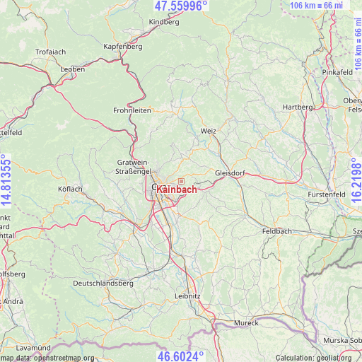
Kainbach GPS coordinates[2]
47° 4' 59.988" North, 15° 31' 0.012" East
| Map corner | latitude | longitude |
|---|---|---|
| Upper-left | 47.55996°, | 14.81355° |
| Center: | 47.08333°, | 15.51667° |
| Lower-right: | 46.6024°, | 16.2198° |
| Map W x H: | 106.5×106.5 km | = 66.2×66.2mi |
| max Lat: | 48.98333° ⇑80.3% North |
| Kainbach: | 47.08333° |
| min Lat: | ⇓19.7% South 46.48841° |
| min Long | Kainbach | max Long |
| 9.57802° | 15.51667° | 17.1° |
| W 65.9%⇐ | ⇒34.1% E |
Elevation
Elevation of Kainbach is 476 m = 1562 ft, and this is 29.5 m = 97 ft below average elevation for this country.
| Max E: |
2140 m = 7021 ft | 46.2% |
| Avg. | 505.5 m = 1658 ft | |
| Kainbach | 476 m = 1562 ft | |
Min E: |
118 m = 387 ft | 53.8% |
See also: Austria elevation on elevation.city.
Geographical zone
Kainbach is located in North temperate zone (between Tropic of Cancer and the Arctic Circle). Distance of this North polar circle is 2166 km =1345.9 mi to North.| Distance of | km | miles | from Kainbach |
|---|---|---|---|
| North Pole | 4771.9 | 2965.1 | to North |
| Arctic Circle | 2166 | 1345.9 | to North |
| Tropic Cancer | 2629.3 | 1633.8 | to South |
| Equator | 5235.2 | 3253 | to South |


Nearby cities:
15 places around Kainbach: (largest is in red/bold)
• Geidorf
5.5 km =3.4 mi,  270°
270°
• Graz
5.4 km =3.4 mi,  249°
249°
• Hart bei Graz
4.5 km =2.8 mi,  181°
181°
• Höf
6 km =3.7 mi,  340°
340°
• Hönigthal
3.8 km =2.4 mi,  90°
90°
• Innere Stadt
6.1 km =3.8 mi, 252°
• Jakomini
6 km =3.7 mi,  237°
237°
• Lassnitzhöhe
5.4 km =3.4 mi,  110°
110°
• Mariatrost
2.2 km =1.4 mi,  325°
325°
• Purgstall
5.3 km =3.3 mi,  45°
45°
• Raaba
5.7 km =3.5 mi,  192°
192°
• Ries
2.4 km =1.5 mi, 269°
• Sankt Leonhard
4.7 km =2.9 mi, 250°
• Sankt Peter
5.3 km =3.3 mi,  225°
225°
• Waltendorf
4.2 km =2.6 mi, 243°
Sources, notices
• [Note1] Compared only with cities in Austria existing in our database
• [Src1] Map data: © OpenStreetMap contributors (CC-BY-SA)
• [Src2] Other city data from geonames.org with taken over terms of usage.
• [Src3] Geographical zone / Annual Mean Temperature by Robert A. Rohde @ Wikipedia
