Innerbraz geodata
Innerbraz (Vorarlberg) is a seat of a third-order administrative division; located in Austria in Europe/Vienna (GMT+2) time zone. With population of 994 people, there are 1300 cities with bigger population in this country. Compared to other cities in Austria, 76% of cities are located further ↑North; 97.4% of cities are located further →East and 87% of cities have lower elevation than Innerbraz. Note1
Administrative division(s):
- Level 1: Vorarlberg
- Level 2: Politischer Bezirk Bludenz
- Level 3: Innerbraz


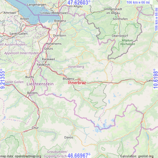
Innerbraz GPS coordinates[2]
47° 9' 0" North, 9° 55' 0.012" East
| Map corner | latitude | longitude |
|---|---|---|
| Upper-left | 47.62603°, | 9.21355° |
| Center: | 47.15°, | 9.91667° |
| Lower-right: | 46.66967°, | 10.6198° |
| Map W x H: | 106.3×106.3 km | = 66.1×66.1mi |
| max Lat: | 48.98333° ⇑76% North |
| Innerbraz: | 47.15° |
| min Lat: | ⇓24% South 46.48841° |
| min Long | Innerbraz | max Long |
| 9.57802° | 9.91667° | 17.1° |
| W 2.6%⇐ | ⇒97.4% E |
Elevation
Elevation of Innerbraz is 827 m = 2713 ft, and this is 321.5 m = 1055 ft above average elevation for this country.
| Max E: |
2140 m = 7021 ft | 13% |
| Innerbraz | 827 m 2713 ft | |
| Avg. | 505.5 m = 1658 ft | |
Min E: |
118 m = 387 ft | 87% |
See also: Austria elevation on elevation.city.
Geographical zone
Innerbraz is located in North temperate zone (between Tropic of Cancer and the Arctic Circle). Distance of this North polar circle is 2158.6 km =1341.3 mi to North.| Distance of | km | miles | from Innerbraz |
|---|---|---|---|
| North Pole | 4764.5 | 2960.5 | to North |
| Arctic Circle | 2158.6 | 1341.3 | to North |
| Tropic Cancer | 2636.7 | 1638.4 | to South |
| Equator | 5242.6 | 3257.6 | to South |


Nearby cities:
15 places around Innerbraz: (largest is in red/bold)
• Ausserbraz
1.2 km =0.7 mi,  263°
263°
• Bartholomäberg
7.5 km =4.7 mi,  189°
189°
• Bludenz
7.1 km =4.4 mi,  274°
274°
• Bürs
8.8 km =5.5 mi, 269°
• Dalaas
6.3 km =3.9 mi,  116°
116°
• Lorüns
5.4 km =3.4 mi,  249°
249°
• Nüziders
9 km =5.6 mi,  281°
281°
• Raggal
9.1 km =5.7 mi,  318°
318°
• Sankt Anton im Montafon
5.3 km =3.3 mi,  225°
225°
• Schruns
9.3 km =5.8 mi,  180°
180°
• Silbertal
8 km =5 mi,  141°
141°
• Stallehr
5.4 km =3.4 mi, 249°
• Tschagguns
7.5 km =4.7 mi, 189°
• Vandans
7.2 km =4.5 mi,  212°
212°
• Wald am Arlberg
9 km =5.6 mi,  101°
101°
Sources, notices
• [Note1] Compared only with cities in Austria existing in our database
• [Src1] Map data: © OpenStreetMap contributors (CC-BY-SA)
• [Src2] Other city data from geonames.org with taken over terms of usage.
• [Src3] Geographical zone / Annual Mean Temperature by Robert A. Rohde @ Wikipedia
