Gunskirchen geodata
Gunskirchen (Upper Austria) is a seat of a third-order administrative division; located in Austria in Europe/Vienna (GMT+2) time zone. With population of 3,778 people, there are 281 cities with bigger population in this country. Compared to other cities in Austria, 74.5% of cities are located further ↓South; 66% of cities are located further →East and 66.4% of cities have higher elevation than Gunskirchen. Note1


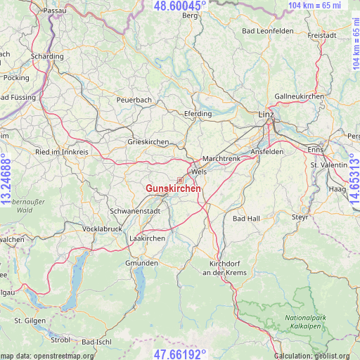
Gunskirchen GPS coordinates[2]
48° 7' 59.988" North, 13° 57' 0" East
| Map corner | latitude | longitude |
|---|---|---|
| Upper-left | 48.60045°, | 13.24688° |
| Center: | 48.13333°, | 13.95° |
| Lower-right: | 47.66192°, | 14.65313° |
| Map W x H: | 104.4×104.4 km | = 64.9×64.9mi |
| max Lat: | 48.98333° ⇑25.5% North |
| Gunskirchen: | 48.13333° |
| min Lat: | ⇓74.5% South 46.48841° |
| min Long | Gunskirchen | max Long |
| 9.57802° | 13.95° | 17.1° |
| W 34%⇐ | ⇒66% E |
Elevation
Elevation of Gunskirchen is 345 m = 1132 ft, and this is 160.5 m = 527 ft below average elevation for this country.
| Max E: |
2140 m = 7021 ft | 66.4% |
| Avg. | 505.5 m = 1658 ft | |
| Gunskirchen | 345 m = 1132 ft | |
Min E: |
118 m = 387 ft | 33.6% |
See also: Austria elevation on elevation.city.
Geographical zone
Gunskirchen is located in North temperate zone (between Tropic of Cancer and the Arctic Circle). Distance of this North polar circle is 2049.2 km =1273.3 mi to North.| Distance of | km | miles | from Gunskirchen |
|---|---|---|---|
| North Pole | 4655.1 | 2892.5 | to North |
| Arctic Circle | 2049.2 | 1273.3 | to North |
| Tropic Cancer | 2746 | 1706.3 | to South |
| Equator | 5351.9 | 3325.5 | to South |


Nearby cities:
15 places around Gunskirchen: (largest is in red/bold)
• Bernardin
5.3 km =3.3 mi,  55°
55°
• Brandln
3.6 km =2.2 mi,  68°
68°
• Edt bei Lambach
5.3 km =3.3 mi,  249°
249°
• Graben
5.2 km =3.2 mi,  225°
225°
• Kropfing
5.8 km =3.6 mi,  216°
216°
• Laahen
6 km =3.7 mi,  44°
44°
• Lichtenegg
4.1 km =2.5 mi, 63°
• Niederthan
6.7 km =4.2 mi,  33°
33°
• Oberhaid
6.8 km =4.2 mi,  45°
45°
• Pichl bei Wels
6.9 km =4.3 mi,  326°
326°
• Steinerkirchen an der Traun
6.1 km =3.8 mi,  174°
174°
• Steinhaus
5.5 km =3.4 mi,  110°
110°
• Thalheim bei Wels
6.5 km =4 mi, 73°
• Wimpassing
4.5 km =2.8 mi, 33°
• Wispl
5 km =3.1 mi, 45°
Sources, notices
• [Note1] Compared only with cities in Austria existing in our database
• [Src1] Map data: © OpenStreetMap contributors (CC-BY-SA)
• [Src2] Other city data from geonames.org with taken over terms of usage.
• [Src3] Geographical zone / Annual Mean Temperature by Robert A. Rohde @ Wikipedia
