Oberhaid geodata
Oberhaid (Upper Austria) is a section of populated place; located in Austria in Europe/Vienna (GMT+2) time zone. With population of 5,100 people, there are 188 cities with bigger population in this country. Compared to other cities in Austria, 77.4% of cities are located further ↓South; 64.7% of cities are located further →East and 71.1% of cities have higher elevation than Oberhaid. Note1


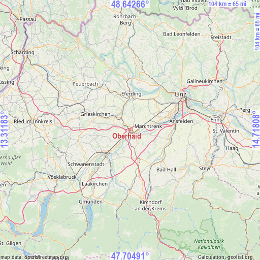
Oberhaid GPS coordinates[2]
48° 10' 33.348" North, 14° 0' 53.82" East
| Map corner | latitude | longitude |
|---|---|---|
| Upper-left | 48.64266°, | 13.31183° |
| Center: | 48.17593°, | 14.01495° |
| Lower-right: | 47.70491°, | 14.71808° |
| Map W x H: | 104.3×104.3 km | = 64.8×64.8mi |
| max Lat: | 48.98333° ⇑22.6% North |
| Oberhaid: | 48.17593° |
| min Lat: | ⇓77.4% South 46.48841° |
| min Long | Oberhaid | max Long |
| 9.57802° | 14.01495° | 17.1° |
| W 35.3%⇐ | ⇒64.7% E |
Elevation
Elevation of Oberhaid is 322 m = 1056 ft, and this is 183.5 m = 602 ft below average elevation for this country.
| Max E: |
2140 m = 7021 ft | 71.1% |
| Avg. | 505.5 m = 1658 ft | |
| Oberhaid | 322 m = 1056 ft | |
Min E: |
118 m = 387 ft | 28.9% |
See also: Austria elevation on elevation.city.
Geographical zone
Oberhaid is located in North temperate zone (between Tropic of Cancer and the Arctic Circle). Distance of this North polar circle is 2044.5 km =1270.4 mi to North.| Distance of | km | miles | from Oberhaid |
|---|---|---|---|
| North Pole | 4650.4 | 2889.6 | to North |
| Arctic Circle | 2044.5 | 1270.4 | to North |
| Tropic Cancer | 2750.7 | 1709.2 | to South |
| Equator | 5356.7 | 3328.5 | to South |


Nearby cities:
15 places around Oberhaid: (largest is in red/bold)
• Bernardin
1.8 km =1.1 mi,  195°
195°
• Brandln
3.7 km =2.3 mi, 203°
• Dickerldorf
3.1 km =1.9 mi,  88°
88°
• Haidl
2.8 km =1.7 mi,  97°
97°
• Hochpoint
2.4 km =1.5 mi,  132°
132°
• Laahen
0.8 km =0.5 mi,  234°
234°
• Lichtenegg
3.1 km =1.9 mi, 201°
• Niederthan
1.4 km =0.9 mi,  306°
306°
• Oberhart
2.7 km =1.7 mi,  72°
72°
• Pernau
1.7 km =1.1 mi, 127°
• Thalheim bei Wels
3.2 km =2 mi,  154°
154°
• Untereisenfeld
2.1 km =1.3 mi,  114°
114°
• Wels
1.7 km =1.1 mi, 127°
• Wimpassing
2.6 km =1.6 mi,  246°
246°
• Wispl
1.8 km =1.1 mi, 226°
Sources, notices
• [Note1] Compared only with cities in Austria existing in our database
• [Src1] Map data: © OpenStreetMap contributors (CC-BY-SA)
• [Src2] Other city data from geonames.org with taken over terms of usage.
• [Src3] Geographical zone / Annual Mean Temperature by Robert A. Rohde @ Wikipedia
