Falkenburg geodata
Falkenburg (Styria) is a populated place; located in Austria in Europe/Vienna (GMT+2) time zone. With population of 1,063 people, there are 1203 cities with bigger population in this country. Compared to other cities in Austria, 53.8% of cities are located further ↑North; 63.3% of cities are located further →East and 76.2% of cities have lower elevation than Falkenburg. Note1
Administrative division(s):
- Level 1: Styria
- Level 2: Politischer Bezirk Liezen
- Level 3: Irdning-Donnersbachtal


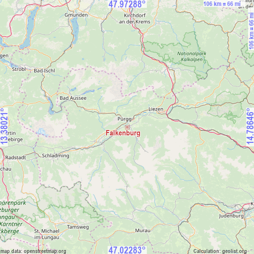
Falkenburg GPS coordinates[2]
47° 30' 0" North, 14° 4' 59.988" East
| Map corner | latitude | longitude |
|---|---|---|
| Upper-left | 47.97288°, | 13.38021° |
| Center: | 47.5°, | 14.08333° |
| Lower-right: | 47.02283°, | 14.78646° |
| Map W x H: | 105.6×105.6 km | = 65.6×65.6mi |
| max Lat: | 48.98333° ⇑53.8% North |
| Falkenburg: | 47.5° |
| min Lat: | ⇓46.2% South 46.48841° |
| min Long | Falkenburg | max Long |
| 9.57802° | 14.08333° | 17.1° |
| W 36.7%⇐ | ⇒63.3% E |
Elevation
Elevation of Falkenburg is 665 m = 2182 ft, and this is 159.5 m = 523 ft above average elevation for this country.
| Max E: |
2140 m = 7021 ft | 23.8% |
| Falkenburg | 665 m 2182 ft | |
| Avg. | 505.5 m = 1658 ft | |
Min E: |
118 m = 387 ft | 76.2% |
See also: Austria elevation on elevation.city.
Geographical zone
Falkenburg is located in North temperate zone (between Tropic of Cancer and the Arctic Circle). Distance of this North polar circle is 2119.7 km =1317.1 mi to North.| Distance of | km | miles | from Falkenburg |
|---|---|---|---|
| North Pole | 4725.6 | 2936.4 | to North |
| Arctic Circle | 2119.7 | 1317.1 | to North |
| Tropic Cancer | 2675.6 | 1662.5 | to South |
| Equator | 5281.5 | 3281.8 | to South |


Nearby cities:
15 places around Falkenburg: (largest is in red/bold)
• Aigen im Ennstal
4.2 km =2.6 mi,  63°
63°
• Donnersbach
5.5 km =3.4 mi,  140°
140°
• Großsölk
12.8 km =8 mi,  223°
223°
• Irdning
1.5 km =0.9 mi,  66°
66°
• Liezen
13.5 km =8.4 mi, 56°
• Mitterberg
10.9 km =6.8 mi,  247°
247°
• Mitterndorf im Steirischen Salzkammergut
12.9 km =8 mi,  298°
298°
• Neuhofen
12.6 km =7.8 mi, 296°
• Niederöblarn
5.5 km =3.4 mi,  241°
241°
• Sankt Martin am Grimming
7.8 km =4.8 mi,  260°
260°
• Stainach
4.2 km =2.6 mi,  27°
27°
• Tauplitz
8.5 km =5.3 mi,  321°
321°
• Weißenbach bei Liezen
12.5 km =7.8 mi,  53°
53°
• Wörschach
7.5 km =4.7 mi,  41°
41°
• Öblarn
8.3 km =5.2 mi, 237°
Sources, notices
• [Note1] Compared only with cities in Austria existing in our database
• [Src1] Map data: © OpenStreetMap contributors (CC-BY-SA)
• [Src2] Other city data from geonames.org with taken over terms of usage.
• [Src3] Geographical zone / Annual Mean Temperature by Robert A. Rohde @ Wikipedia
