Esternberg geodata
Esternberg (Upper Austria) is a populated place; located in Austria in Europe/Vienna (GMT+2) time zone. With population of 670 people, there are 1932 cities with bigger population in this country. Compared to other cities in Austria, 95.4% of cities are located further ↓South; 74% of cities are located further →East and 57.8% of cities have lower elevation than Esternberg. Note1
Administrative division(s):
- Level 1: Upper Austria
- Level 2: Politischer Bezirk Schärding
- Level 3: Esternberg


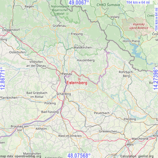
Esternberg GPS coordinates[2]
48° 32' 35.988" North, 13° 34' 14.988" East
| Map corner | latitude | longitude |
|---|---|---|
| Upper-left | 49.0067°, | 12.86771° |
| Center: | 48.54333°, | 13.57083° |
| Lower-right: | 48.07568°, | 14.27396° |
| Map W x H: | 103.5×103.5 km | = 64.3×64.3mi |
| max Lat: | 48.98333° ⇑4.6% North |
| Esternberg: | 48.54333° |
| min Lat: | ⇓95.4% South 46.48841° |
| min Long | Esternberg | max Long |
| 9.57802° | 13.57083° | 17.1° |
| W 26%⇐ | ⇒74% E |
Elevation
Elevation of Esternberg is 504 m = 1654 ft, and this is 1.5 m = 5 ft below average elevation for this country.
| Max E: |
2140 m = 7021 ft | 42.2% |
| Avg. | 505.5 m = 1658 ft | |
| Esternberg | 504 m = 1654 ft | |
Min E: |
118 m = 387 ft | 57.8% |
See also: Austria elevation on elevation.city.
Geographical zone
Esternberg is located in North temperate zone (between Tropic of Cancer and the Arctic Circle). Distance of this North polar circle is 2003.7 km =1245 mi to North.| Distance of | km | miles | from Esternberg |
|---|---|---|---|
| North Pole | 4609.5 | 2864.2 | to North |
| Arctic Circle | 2003.7 | 1245 | to North |
| Tropic Cancer | 2791.6 | 1734.6 | to South |
| Equator | 5397.5 | 3353.8 | to South |


Nearby cities:
15 places around Esternberg: (largest is in red/bold)
• Allerheiligen
12.9 km =8 mi,  228°
228°
• Bubing
12.8 km =8 mi,  219°
219°
• Kopfing im Innkreis
13.2 km =8.2 mi,  150°
150°
• Münzkirchen
6.7 km =4.2 mi,  182°
182°
• Neustift im Mühlkreis
13.8 km =8.6 mi,  96°
96°
• Sankt Aegidi
14.2 km =8.8 mi,  120°
120°
• Sankt Roman
7.4 km =4.6 mi,  156°
156°
• Schardenberg
5.9 km =3.7 mi,  244°
244°
• Schärding
14.1 km =8.8 mi, 224°
• Schärding Innere Stadt
14.1 km =8.8 mi, 227°
• Schärding Vorstadt
14 km =8.7 mi, 223°
• Sigharting
16.4 km =10.2 mi,  173°
173°
• Suben
17.9 km =11.1 mi, 215°
• Taufkirchen an der Pram
14.9 km =9.3 mi,  188°
188°
• Wernstein am Inn
9 km =5.6 mi, 244°
Sources, notices
• [Note1] Compared only with cities in Austria existing in our database
• [Src1] Map data: © OpenStreetMap contributors (CC-BY-SA)
• [Src2] Other city data from geonames.org with taken over terms of usage.
• [Src3] Geographical zone / Annual Mean Temperature by Robert A. Rohde @ Wikipedia
