Dickerldorf geodata
Dickerldorf (Upper Austria) is a section of populated place; located in Austria in Europe/Vienna (GMT+2) time zone. With population of 1,003 people, there are 1288 cities with bigger population in this country. Compared to other cities in Austria, 77.5% of cities are located further ↓South; 63.6% of cities are located further →East and 73.5% of cities have higher elevation than Dickerldorf. Note1


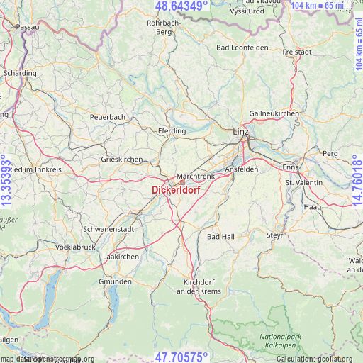
Dickerldorf GPS coordinates[2]
48° 10' 36.336" North, 14° 3' 25.38" East
| Map corner | latitude | longitude |
|---|---|---|
| Upper-left | 48.64349°, | 13.35393° |
| Center: | 48.17676°, | 14.05705° |
| Lower-right: | 47.70575°, | 14.76018° |
| Map W x H: | 104.3×104.3 km | = 64.8×64.8mi |
| max Lat: | 48.98333° ⇑22.5% North |
| Dickerldorf: | 48.17676° |
| min Lat: | ⇓77.5% South 46.48841° |
| min Long | Dickerldorf | max Long |
| 9.57802° | 14.05705° | 17.1° |
| W 36.4%⇐ | ⇒63.6% E |
Elevation
Elevation of Dickerldorf is 311 m = 1020 ft, and this is 194.5 m = 638 ft below average elevation for this country.
| Max E: |
2140 m = 7021 ft | 73.5% |
| Avg. | 505.5 m = 1658 ft | |
| Dickerldorf | 311 m = 1020 ft | |
Min E: |
118 m = 387 ft | 26.5% |
See also: Austria elevation on elevation.city.
Geographical zone
Dickerldorf is located in North temperate zone (between Tropic of Cancer and the Arctic Circle). Distance of this North polar circle is 2044.4 km =1270.3 mi to North.| Distance of | km | miles | from Dickerldorf |
|---|---|---|---|
| North Pole | 4650.3 | 2889.6 | to North |
| Arctic Circle | 2044.4 | 1270.3 | to North |
| Tropic Cancer | 2750.8 | 1709.3 | to South |
| Equator | 5356.8 | 3328.6 | to South |


Nearby cities:
15 places around Dickerldorf: (largest is in red/bold)
• Au an der Traun
4.1 km =2.5 mi,  84°
84°
• Bernardin
4 km =2.5 mi,  243°
243°
• Haidl
0.5 km =0.3 mi,  213°
213°
• Hochpoint
2.2 km =1.4 mi,  219°
219°
• Laahen
3.8 km =2.4 mi,  261°
261°
• Mitterperwend
4.1 km =2.5 mi,  39°
39°
• Oberhaid
3.1 km =1.9 mi,  268°
268°
• Oberhart
0.9 km =0.6 mi,  324°
324°
• Pernau
2.1 km =1.3 mi, 237°
• Schafwiesen
1.3 km =0.8 mi,  147°
147°
• Schleissheim
2.2 km =1.4 mi,  143°
143°
• Thalheim bei Wels
3.5 km =2.2 mi, 210°
• Untereisenfeld
1.5 km =0.9 mi,  230°
230°
• Unterhart
3.3 km =2.1 mi,  51°
51°
• Wels
2.1 km =1.3 mi, 237°
Sources, notices
• [Note1] Compared only with cities in Austria existing in our database
• [Src1] Map data: © OpenStreetMap contributors (CC-BY-SA)
• [Src2] Other city data from geonames.org with taken over terms of usage.
• [Src3] Geographical zone / Annual Mean Temperature by Robert A. Rohde @ Wikipedia
