Spearwood geodata
Spearwood (Western Australia) is a section of populated place; located in Australia in Australia/Perth (GMT+8) time zone. With population of 9,872 people, there are 614 cities with bigger population in this country. Compared to other cities in Australia, 63.5% of cities are located further ↓South; 96.7% of cities are located further →East and 96.8% of cities have higher elevation than Spearwood. Note1


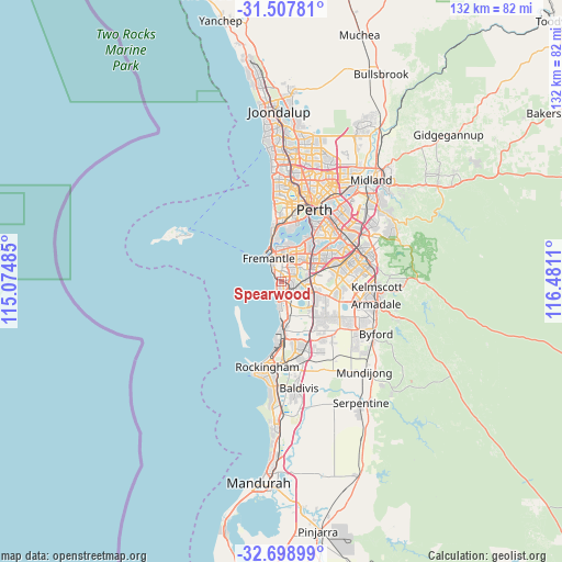
Spearwood GPS coordinates[2]
32° 6' 19.224" South, 115° 46' 40.692" East
| Map corner | latitude | longitude |
|---|---|---|
| Upper-left | -31.50781°, | 115.07485° |
| Center: | -32.10534°, | 115.77797° |
| Lower-right: | -32.69899°, | 116.4811° |
| Map W x H: | 132.4×132.4 km | = 82.3×82.3mi |
| max Lat: | -10.58257° ⇑36.5% North |
| Spearwood: | -32.10534° |
| min Lat: | ⇓63.5% South -43.31423° |
| min Long | Spearwood | max Long |
| 113.53327° | 115.77797° | 153.61246° |
| W 3.3%⇐ | ⇒96.7% E |
Elevation
Elevation of Spearwood is 5 m = 16 ft, and this is 117 m = 384 ft below average elevation for this country.
| Max E: |
1715 m = 5627 ft | 96.8% |
| Avg. | 122 m = 400 ft | |
| Spearwood | 5 m = 16 ft | |
Min E: |
-2 m = -7 ft | 3.2% |
See also: Australia elevation on elevation.city.
Geographical zone
Spearwood is located in South temperate zone (between Tropic of Capricorn and the Antarctic Circle). Distance of this Southern Tropic circle is 963.9 km =598.9 mi to North.| Distance of | km | miles | from Spearwood |
|---|---|---|---|
| Equator | 3569.8 | 2218.2 | to North |
| Tropic Capricorn | 963.9 | 598.9 | to North |
| Antarctic Circle | 3831.4 | 2380.7 | to South |
| South Pole | 6437.3 | 4000 | to South |


Nearby cities:
15 places around Spearwood: (largest is in red/bold)
• Beaconsfield
4.4 km =2.7 mi,  342°
342°
• Beeliar
4.1 km =2.5 mi,  139°
139°
• Bibra Lake
4 km =2.5 mi,  77°
77°
• Coogee
1.9 km =1.2 mi,  214°
214°
• Coolbellup
3.8 km =2.4 mi,  44°
44°
• Hamilton Hill
2.3 km =1.4 mi,  3°
3°
• Hilton
4.8 km =3 mi, 2°
• Kardinya
5.6 km =3.5 mi, 38°
• Munster
3.5 km =2.2 mi,  172°
172°
• North Coogee
2.1 km =1.3 mi,  303°
303°
• Samson
4.4 km =2.7 mi,  25°
25°
• South Fremantle
4.6 km =2.9 mi,  331°
331°
• South Lake
5.8 km =3.6 mi,  96°
96°
• White Gum Valley
5.1 km =3.2 mi,  352°
352°
• Yangebup
4 km =2.5 mi,  115°
115°
Sources, notices
• [Note1] Compared only with cities in Australia existing in our database
• [Src1] Map data: © OpenStreetMap contributors (CC-BY-SA)
• [Src2] Other city data from geonames.org with taken over terms of usage.
• [Src3] Geographical zone / Annual Mean Temperature by Robert A. Rohde @ Wikipedia
