Munster geodata
Munster (Western Australia) is a section of populated place; located in Australia in Australia/Perth (GMT+8) time zone. With population of 4,314 people, there are 1677 cities with bigger population in this country. Compared to other cities in Australia, 63.2% of cities are located further ↓South; 96.5% of cities are located further →East and 98.1% of cities have higher elevation than Munster. Note1


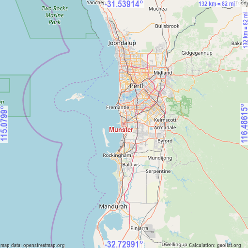
Munster GPS coordinates[2]
32° 8' 11.292" South, 115° 46' 58.872" East
| Map corner | latitude | longitude |
|---|---|---|
| Upper-left | -31.53914°, | 115.0799° |
| Center: | -32.13647°, | 115.78302° |
| Lower-right: | -32.72991°, | 116.48615° |
| Map W x H: | 132.4×132.4 km | = 82.3×82.3mi |
| max Lat: | -10.58257° ⇑36.8% North |
| Munster: | -32.13647° |
| min Lat: | ⇓63.2% South -43.31423° |
| min Long | Munster | max Long |
| 113.53327° | 115.78302° | 153.61246° |
| W 3.5%⇐ | ⇒96.5% E |
Elevation
Elevation of Munster is 4 m = 13 ft, and this is 118 m = 387 ft below average elevation for this country.
| Max E: |
1715 m = 5627 ft | 98.1% |
| Avg. | 122 m = 400 ft | |
| Munster | 4 m = 13 ft | |
Min E: |
-2 m = -7 ft | 1.9% |
See also: Australia elevation on elevation.city.
Geographical zone
Munster is located in South temperate zone (between Tropic of Capricorn and the Antarctic Circle). Distance of this Southern Tropic circle is 967.3 km =601.1 mi to North.| Distance of | km | miles | from Munster |
|---|---|---|---|
| Equator | 3573.2 | 2220.3 | to North |
| Tropic Capricorn | 967.3 | 601.1 | to North |
| Antarctic Circle | 3827.9 | 2378.5 | to South |
| South Pole | 6433.8 | 3997.8 | to South |


Nearby cities:
15 places around Munster: (largest is in red/bold)
• Beeliar
2.2 km =1.4 mi,  81°
81°
• Bibra Lake
5.5 km =3.4 mi,  38°
38°
• City of Cockburn
6.9 km =4.3 mi,  56°
56°
• Cockburn Central
6.3 km =3.9 mi,  74°
74°
• Coogee
2.5 km =1.6 mi,  320°
320°
• Coolbellup
6.5 km =4 mi,  19°
19°
• Hamilton Hill
5.8 km =3.6 mi,  356°
356°
• Hammond Park
7.3 km =4.5 mi,  119°
119°
• North Coogee
5.1 km =3.2 mi,  334°
334°
• North Lake
7.8 km =4.8 mi, 39°
• Samson
7.5 km =4.7 mi,  10°
10°
• South Lake
5.9 km =3.7 mi, 61°
• Spearwood
3.5 km =2.2 mi,  352°
352°
• Success
6.3 km =3.9 mi,  96°
96°
• Yangebup
3.6 km =2.2 mi, 60°
Sources, notices
• [Note1] Compared only with cities in Australia existing in our database
• [Src1] Map data: © OpenStreetMap contributors (CC-BY-SA)
• [Src2] Other city data from geonames.org with taken over terms of usage.
• [Src3] Geographical zone / Annual Mean Temperature by Robert A. Rohde @ Wikipedia
