Semaphore geodata
Semaphore (South Australia) is a section of populated place; located in Australia in Australia/Adelaide (GMT+10.5) time zone. With population of 2,727 people, there are 2423 cities with bigger population in this country. Compared to other cities in Australia, 66.4% of cities are located further ↑North; 84.8% of cities are located further →East and 81.9% of cities have higher elevation than Semaphore. Note1


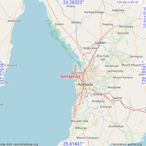
Semaphore GPS coordinates[2]
34° 50' 21.624" South, 138° 28' 56.208" East
| Map corner | latitude | longitude |
|---|---|---|
| Upper-left | -34.26023°, | 137.77916° |
| Center: | -34.83934°, | 138.48228° |
| Lower-right: | -35.41441°, | 139.18541° |
| Map W x H: | 128.3×128.3 km | = 79.7×79.7mi |
| max Lat: | -10.58257° ⇑66.4% North |
| Semaphore: | -34.83934° |
| min Lat: | ⇓33.6% South -43.31423° |
| min Long | Semaphore | max Long |
| 113.53327° | 138.48228° | 153.61246° |
| W 15.2%⇐ | ⇒84.8% E |
Elevation
Elevation of Semaphore is 14 m = 46 ft, and this is 108 m = 354 ft below average elevation for this country.
| Max E: |
1715 m = 5627 ft | 81.9% |
| Avg. | 122 m = 400 ft | |
| Semaphore | 14 m = 46 ft | |
Min E: |
-2 m = -7 ft | 18.1% |
See also: Australia elevation on elevation.city.
Geographical zone
Semaphore is located in South temperate zone (between Tropic of Capricorn and the Antarctic Circle). Distance of this Southern Tropic circle is 1267.9 km =787.8 mi to North.| Distance of | km | miles | from Semaphore |
|---|---|---|---|
| Equator | 3873.8 | 2407.1 | to North |
| Tropic Capricorn | 1267.9 | 787.8 | to North |
| Antarctic Circle | 3527.4 | 2191.8 | to South |
| South Pole | 6133.3 | 3811.1 | to South |


Nearby cities:
15 places around Semaphore: (largest is in red/bold)
• Birkenhead
1.5 km =0.9 mi,  78°
78°
• Ethelton
1.3 km =0.8 mi,  142°
142°
• Exeter
0.6 km =0.4 mi,  96°
96°
• Glanville
0.9 km =0.6 mi,  127°
127°
• Largs Bay
1.5 km =0.9 mi,  13°
13°
• Largs North
2.3 km =1.4 mi,  23°
23°
• New Port
1.2 km =0.7 mi,  116°
116°
• Peterhead
1.8 km =1.1 mi,  59°
59°
• Port Adelaide
2 km =1.2 mi,  111°
111°
• Queenstown
3.5 km =2.2 mi, 132°
• Rosewater
3.9 km =2.4 mi, 111°
• Semaphore Park
1.3 km =0.8 mi,  193°
193°
• Semaphore South
1.2 km =0.7 mi, 192°
• West Lakes
3.9 km =2.4 mi,  163°
163°
• West Lakes Shore
2.4 km =1.5 mi, 163°
Sources, notices
• [Note1] Compared only with cities in Australia existing in our database
• [Src1] Map data: © OpenStreetMap contributors (CC-BY-SA)
• [Src2] Other city data from geonames.org with taken over terms of usage.
• [Src3] Geographical zone / Annual Mean Temperature by Robert A. Rohde @ Wikipedia
