Queenstown geodata
Queenstown (South Australia) is a section of populated place; located in Australia in Australia/Adelaide (GMT+10.5) time zone. With population of 1,865 people, there are 2997 cities with bigger population in this country. Compared to other cities in Australia, 67% of cities are located further ↑North; 84.3% of cities are located further →East and 93.8% of cities have higher elevation than Queenstown. Note1


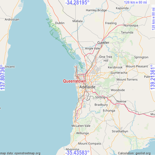
Queenstown GPS coordinates[2]
34° 51' 39.276" South, 138° 30' 37.728" East
| Map corner | latitude | longitude |
|---|---|---|
| Upper-left | -34.28195°, | 137.80736° |
| Center: | -34.86091°, | 138.51048° |
| Lower-right: | -35.43583°, | 139.21361° |
| Map W x H: | 128.3×128.3 km | = 79.7×79.7mi |
| max Lat: | -10.58257° ⇑67% North |
| Queenstown: | -34.86091° |
| min Lat: | ⇓33% South -43.31423° |
| min Long | Queenstown | max Long |
| 113.53327° | 138.51048° | 153.61246° |
| W 15.7%⇐ | ⇒84.3% E |
Elevation
Elevation of Queenstown is 7 m = 23 ft, and this is 115 m = 377 ft below average elevation for this country.
| Max E: |
1715 m = 5627 ft | 93.8% |
| Avg. | 122 m = 400 ft | |
| Queenstown | 7 m = 23 ft | |
Min E: |
-2 m = -7 ft | 6.2% |
See also: Australia elevation on elevation.city.
Geographical zone
Queenstown is located in South temperate zone (between Tropic of Capricorn and the Antarctic Circle). Distance of this Southern Tropic circle is 1270.3 km =789.3 mi to North.| Distance of | km | miles | from Queenstown |
|---|---|---|---|
| Equator | 3876.2 | 2408.6 | to North |
| Tropic Capricorn | 1270.3 | 789.3 | to North |
| Antarctic Circle | 3525 | 2190.3 | to South |
| South Pole | 6130.9 | 3809.6 | to South |


Nearby cities:
15 places around Queenstown: (largest is in red/bold)
• Albert Park
1.5 km =0.9 mi,  145°
145°
• Alberton
1 km =0.6 mi,  79°
79°
• Athol Park
3 km =1.9 mi, 79°
• Birkenhead
2.9 km =1.8 mi,  336°
336°
• Cheltenham
1.4 km =0.9 mi,  123°
123°
• Ethelton
2.2 km =1.4 mi,  307°
307°
• Glanville
2.6 km =1.6 mi,  315°
315°
• New Port
2.4 km =1.5 mi, 321°
• Ottoway
2.7 km =1.7 mi,  57°
57°
• Pennington
2 km =1.2 mi, 79°
• Port Adelaide
1.8 km =1.1 mi, 337°
• Rosewater
1.4 km =0.9 mi,  45°
45°
• Royal Park
1.5 km =0.9 mi,  175°
175°
• West Lakes
2 km =1.2 mi,  227°
227°
• West Lakes Shore
1.9 km =1.2 mi,  272°
272°
Sources, notices
• [Note1] Compared only with cities in Australia existing in our database
• [Src1] Map data: © OpenStreetMap contributors (CC-BY-SA)
• [Src2] Other city data from geonames.org with taken over terms of usage.
• [Src3] Geographical zone / Annual Mean Temperature by Robert A. Rohde @ Wikipedia
