Rockingham geodata
Rockingham (Western Australia) is a seat of a second-order administrative division; located in Australia in Australia/Perth (GMT+8) time zone. With population of 108,022 people, there are 16 cities with bigger population in this country. Compared to other cities in Australia, 62.4% of cities are located further ↓South; 97.9% of cities are located further →East and 99.9% of cities have higher elevation than Rockingham. Note1


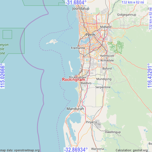
Rockingham GPS coordinates[2]
32° 16' 36.552" South, 115° 43' 47.208" East
| Map corner | latitude | longitude |
|---|---|---|
| Upper-left | -31.6804°, | 115.02666° |
| Center: | -32.27682°, | 115.72978° |
| Lower-right: | -32.86934°, | 116.43291° |
| Map W x H: | 132.2×132.2 km | = 82.1×82.1mi |
| max Lat: | -10.58257° ⇑37.6% North |
| Rockingham: | -32.27682° |
| min Lat: | ⇓62.4% South -43.31423° |
| min Long | Rockingham | max Long |
| 113.53327° | 115.72978° | 153.61246° |
| W 2.1%⇐ | ⇒97.9% E |
Elevation
Elevation of Rockingham is 1 m = 3 ft, and this is 121 m = 397 ft below average elevation for this country.
| Max E: |
1715 m = 5627 ft | 99.9% |
| Avg. | 122 m = 400 ft | |
| Rockingham | 1 m = 3 ft | |
Min E: |
-2 m = -7 ft | 0.1% |
See also: Rockingham elevation on elevation.city.
Geographical zone
Rockingham is located in South temperate zone (between Tropic of Capricorn and the Antarctic Circle). Distance of this Southern Tropic circle is 982.9 km =610.7 mi to North.| Distance of | km | miles | from Rockingham |
|---|---|---|---|
| Equator | 3588.8 | 2230 | to North |
| Tropic Capricorn | 982.9 | 610.7 | to North |
| Antarctic Circle | 3812.3 | 2368.9 | to South |
| South Pole | 6418.2 | 3988.1 | to South |


Nearby cities:
15 places around Rockingham: (largest is in red/bold)
• Calista
7.5 km =4.7 mi,  58°
58°
• Cooloongup
6.2 km =3.9 mi,  133°
133°
• Garden Island
5 km =3.1 mi,  319°
319°
• Hillman
3.3 km =2.1 mi,  102°
102°
• Kwinana
7.1 km =4.4 mi,  43°
43°
• Leda
6.6 km =4.1 mi,  81°
81°
• Medina
8.1 km =5 mi,  53°
53°
• Orelia
10 km =6.2 mi, 60°
• Parmelia
8.9 km =5.5 mi, 76°
• Rockingham city centre
1 km =0.6 mi,  146°
146°
• Safety Bay
3.3 km =2.1 mi,  159°
159°
• Shoalwater
2.4 km =1.5 mi,  228°
228°
• Waikiki
4.9 km =3 mi, 151°
• Warnbro
7.2 km =4.5 mi,  166°
166°
• Wellard
9.8 km =6.1 mi, 83°
Sources, notices
• [Note1] Compared only with cities in Australia existing in our database
• [Src1] Map data: © OpenStreetMap contributors (CC-BY-SA)
• [Src2] Other city data from geonames.org with taken over terms of usage.
• [Src3] Geographical zone / Annual Mean Temperature by Robert A. Rohde @ Wikipedia
