Orelia geodata
Orelia (Western Australia) is a section of populated place; located in Australia in Australia/Perth (GMT+8) time zone. With population of 4,549 people, there are 1614 cities with bigger population in this country. Compared to other cities in Australia, 62.7% of cities are located further ↓South; 95.5% of cities are located further →East and 51.7% of cities have higher elevation than Orelia. Note1


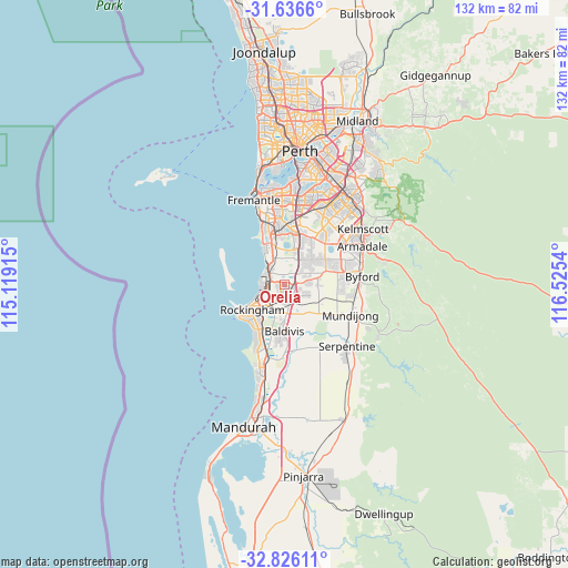
Orelia GPS coordinates[2]
32° 13' 59.88" South, 115° 49' 20.172" East
| Map corner | latitude | longitude |
|---|---|---|
| Upper-left | -31.6366°, | 115.11915° |
| Center: | -32.2333°, | 115.82227° |
| Lower-right: | -32.82611°, | 116.5254° |
| Map W x H: | 132.3×132.3 km | = 82.2×82.2mi |
| max Lat: | -10.58257° ⇑37.3% North |
| Orelia: | -32.2333° |
| min Lat: | ⇓62.7% South -43.31423° |
| min Long | Orelia | max Long |
| 113.53327° | 115.82227° | 153.61246° |
| W 4.5%⇐ | ⇒95.5% E |
Elevation
Elevation of Orelia is 43 m = 141 ft, and this is 79 m = 259 ft below average elevation for this country.
| Max E: |
1715 m = 5627 ft | 51.7% |
| Avg. | 122 m = 400 ft | |
| Orelia | 43 m = 141 ft | |
Min E: |
-2 m = -7 ft | 48.3% |
See also: Australia elevation on elevation.city.
Geographical zone
Orelia is located in South temperate zone (between Tropic of Capricorn and the Antarctic Circle). Distance of this Southern Tropic circle is 978.1 km =607.8 mi to North.| Distance of | km | miles | from Orelia |
|---|---|---|---|
| Equator | 3584 | 2227 | to North |
| Tropic Capricorn | 978.1 | 607.8 | to North |
| Antarctic Circle | 3817.2 | 2371.9 | to South |
| South Pole | 6423.1 | 3991.1 | to South |


Nearby cities:
15 places around Orelia: (largest is in red/bold)
• Aubin Grove
8.3 km =5.2 mi,  27°
27°
• Bertram
2.5 km =1.6 mi,  117°
117°
• Calista
2.5 km =1.6 mi,  249°
249°
• Casuarina
4.6 km =2.9 mi,  101°
101°
• Cooloongup
10 km =6.2 mi,  204°
204°
• Hammond Park
7.7 km =4.8 mi,  20°
20°
• Hillman
7.8 km =4.8 mi,  224°
224°
• Kwinana
3.9 km =2.4 mi,  275°
275°
• Leda
4.4 km =2.7 mi,  209°
209°
• Medina
2.2 km =1.4 mi,  267°
267°
• Parmelia
2.7 km =1.7 mi,  180°
180°
• Rockingham
10 km =6.2 mi,  240°
240°
• Rockingham city centre
9.9 km =6.2 mi, 235°
• Wandi
6.7 km =4.2 mi,  49°
49°
• Wellard
3.9 km =2.4 mi,  164°
164°
Sources, notices
• [Note1] Compared only with cities in Australia existing in our database
• [Src1] Map data: © OpenStreetMap contributors (CC-BY-SA)
• [Src2] Other city data from geonames.org with taken over terms of usage.
• [Src3] Geographical zone / Annual Mean Temperature by Robert A. Rohde @ Wikipedia
