Penfield geodata
Penfield (South Australia) is a populated place; located in Australia in Australia/Adelaide (GMT+10.5) time zone. With population of 792 people, there are 4166 cities with bigger population in this country. Compared to other cities in Australia, 64.7% of cities are located further ↑North; 79.9% of cities are located further →East and 69.8% of cities have higher elevation than Penfield. Note1


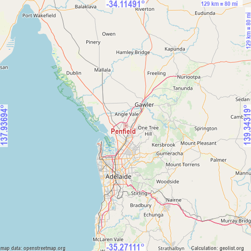
Penfield GPS coordinates[2]
34° 41' 42.108" South, 138° 38' 24.216" East
| Map corner | latitude | longitude |
|---|---|---|
| Upper-left | -34.11491°, | 137.93694° |
| Center: | -34.69503°, | 138.64006° |
| Lower-right: | -35.27111°, | 139.34319° |
| Map W x H: | 128.6×128.6 km | = 79.9×79.9mi |
| max Lat: | -10.58257° ⇑64.7% North |
| Penfield: | -34.69503° |
| min Lat: | ⇓35.3% South -43.31423° |
| min Long | Penfield | max Long |
| 113.53327° | 138.64006° | 153.61246° |
| W 20.1%⇐ | ⇒79.9% E |
Elevation
Elevation of Penfield is 23 m = 75 ft, and this is 99 m = 325 ft below average elevation for this country.
| Max E: |
1715 m = 5627 ft | 69.8% |
| Avg. | 122 m = 400 ft | |
| Penfield | 23 m = 75 ft | |
Min E: |
-2 m = -7 ft | 30.2% |
See also: Australia elevation on elevation.city.
Geographical zone
Penfield is located in South temperate zone (between Tropic of Capricorn and the Antarctic Circle). Distance of this Southern Tropic circle is 1251.8 km =777.8 mi to North.| Distance of | km | miles | from Penfield |
|---|---|---|---|
| Equator | 3857.7 | 2397.1 | to North |
| Tropic Capricorn | 1251.8 | 777.8 | to North |
| Antarctic Circle | 3543.4 | 2201.8 | to South |
| South Pole | 6149.3 | 3821 | to South |


Nearby cities:
15 places around Penfield: (largest is in red/bold)
• Andrews Farm
2.9 km =1.8 mi,  43°
43°
• Burton
5.5 km =3.4 mi,  218°
218°
• Davoren Park
2.7 km =1.7 mi,  79°
79°
• Direk
4.6 km =2.9 mi,  230°
230°
• Elizabeth
4.3 km =2.7 mi,  128°
128°
• Elizabeth Downs
4.7 km =2.9 mi,  96°
96°
• Elizabeth East
5.1 km =3.2 mi, 131°
• Elizabeth Grove
5.2 km =3.2 mi,  149°
149°
• Elizabeth North
3.5 km =2.2 mi,  111°
111°
• Elizabeth Park
4.5 km =2.8 mi, 111°
• Elizabeth South
4.6 km =2.9 mi, 153°
• MacDonald Park
4.1 km =2.5 mi,  4°
4°
• Munno Para West
5 km =3.1 mi,  47°
47°
• Smithfield
4.2 km =2.6 mi,  71°
71°
• Smithfield Plains
4 km =2.5 mi,  59°
59°
Sources, notices
• [Note1] Compared only with cities in Australia existing in our database
• [Src1] Map data: © OpenStreetMap contributors (CC-BY-SA)
• [Src2] Other city data from geonames.org with taken over terms of usage.
• [Src3] Geographical zone / Annual Mean Temperature by Robert A. Rohde @ Wikipedia
