Elizabeth geodata
Elizabeth (South Australia) is a populated place; located in Australia in Australia/Adelaide (GMT+10.5) time zone. With population of 993 people, there are 3833 cities with bigger population in this country. Compared to other cities in Australia, 65% of cities are located further ↑North; 78.7% of cities are located further →East and 50.2% of cities have lower elevation than Elizabeth. Note1


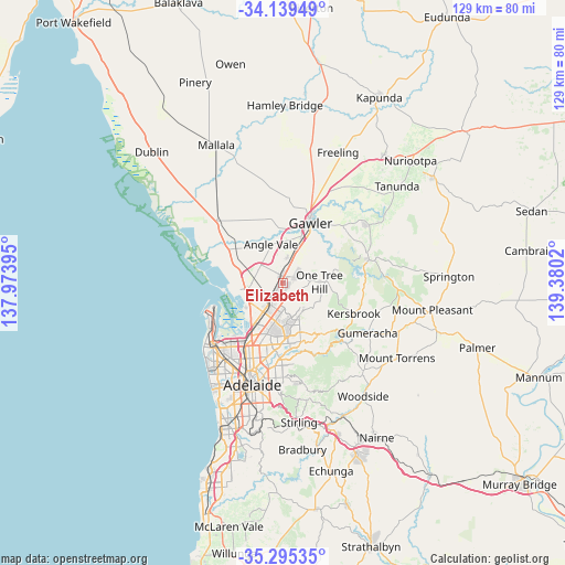
Elizabeth GPS coordinates[2]
34° 43' 9.984" South, 138° 40' 37.452" East
| Map corner | latitude | longitude |
|---|---|---|
| Upper-left | -34.13949°, | 137.97395° |
| Center: | -34.71944°, | 138.67707° |
| Lower-right: | -35.29535°, | 139.3802° |
| Map W x H: | 128.5×128.5 km | = 79.8×79.8mi |
| max Lat: | -10.58257° ⇑65% North |
| Elizabeth: | -34.71944° |
| min Lat: | ⇓35% South -43.31423° |
| min Long | Elizabeth | max Long |
| 113.53327° | 138.67707° | 153.61246° |
| W 21.3%⇐ | ⇒78.7% E |
Elevation
Elevation of Elizabeth is 46 m = 151 ft, and this is 76 m = 249 ft below average elevation for this country.
| Max E: |
1715 m = 5627 ft | 49.8% |
| Avg. | 122 m = 400 ft | |
| Elizabeth | 46 m = 151 ft | |
Min E: |
-2 m = -7 ft | 50.2% |
See also: Australia elevation on elevation.city.
Geographical zone
Elizabeth is located in South temperate zone (between Tropic of Capricorn and the Antarctic Circle). Distance of this Southern Tropic circle is 1254.5 km =779.5 mi to North.| Distance of | km | miles | from Elizabeth |
|---|---|---|---|
| Equator | 3860.4 | 2398.7 | to North |
| Tropic Capricorn | 1254.5 | 779.5 | to North |
| Antarctic Circle | 3540.7 | 2200.1 | to South |
| South Pole | 6146.6 | 3819.3 | to South |


Nearby cities:
15 places around Elizabeth: (largest is in red/bold)
• Craigmore
3.6 km =2.2 mi,  54°
54°
• Davoren Park
3.3 km =2.1 mi,  346°
346°
• Elizabeth Downs
2.5 km =1.6 mi,  30°
30°
• Elizabeth East
0.8 km =0.5 mi,  143°
143°
• Elizabeth Grove
1.9 km =1.2 mi,  203°
203°
• Elizabeth North
1.4 km =0.9 mi,  356°
356°
• Elizabeth Park
1.4 km =0.9 mi,  37°
37°
• Elizabeth South
2 km =1.2 mi,  225°
225°
• Elizabeth Vale
3.3 km =2.1 mi,  194°
194°
• Hillbank
2.1 km =1.3 mi,  153°
153°
• Penfield
4.3 km =2.7 mi,  308°
308°
• Salisbury Heights
4.9 km =3 mi,  181°
181°
• Salisbury Park
4.7 km =2.9 mi, 187°
• Smithfield
4.1 km =2.5 mi,  8°
8°
• Smithfield Plains
4.8 km =3 mi,  0°
0°
Sources, notices
• [Note1] Compared only with cities in Australia existing in our database
• [Src1] Map data: © OpenStreetMap contributors (CC-BY-SA)
• [Src2] Other city data from geonames.org with taken over terms of usage.
• [Src3] Geographical zone / Annual Mean Temperature by Robert A. Rohde @ Wikipedia
