Marion geodata
Marion (South Australia) is a populated place; located in Australia in Australia/Adelaide (GMT+10.5) time zone. With population of 3,783 people, there are 1881 cities with bigger population in this country. Compared to other cities in Australia, 71.4% of cities are located further ↑North; 82.9% of cities are located further →East and 63.7% of cities have higher elevation than Marion. Note1


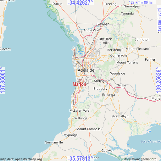
Marion GPS coordinates[2]
35° 0' 15.228" South, 138° 33' 11.268" East
| Map corner | latitude | longitude |
|---|---|---|
| Upper-left | -34.42627°, | 137.85001° |
| Center: | -35.00423°, | 138.55313° |
| Lower-right: | -35.57813°, | 139.25626° |
| Map W x H: | 128.1×128.1 km | = 79.6×79.6mi |
| max Lat: | -10.58257° ⇑71.4% North |
| Marion: | -35.00423° |
| min Lat: | ⇓28.6% South -43.31423° |
| min Long | Marion | max Long |
| 113.53327° | 138.55313° | 153.61246° |
| W 17.1%⇐ | ⇒82.9% E |
Elevation
Elevation of Marion is 28 m = 92 ft, and this is 94 m = 308 ft below average elevation for this country.
| Max E: |
1715 m = 5627 ft | 63.7% |
| Avg. | 122 m = 400 ft | |
| Marion | 28 m = 92 ft | |
Min E: |
-2 m = -7 ft | 36.3% |
See also: Australia elevation on elevation.city.
Geographical zone
Marion is located in South temperate zone (between Tropic of Capricorn and the Antarctic Circle). Distance of this Southern Tropic circle is 1286.2 km =799.2 mi to North.| Distance of | km | miles | from Marion |
|---|---|---|---|
| Equator | 3892.1 | 2418.4 | to North |
| Tropic Capricorn | 1286.2 | 799.2 | to North |
| Antarctic Circle | 3509.1 | 2180.5 | to South |
| South Pole | 6115 | 3799.7 | to South |


Nearby cities:
15 places around Marion: (largest is in red/bold)
• Ascot Park
1.4 km =0.9 mi,  16°
16°
• Bedford Park
2.4 km =1.5 mi,  145°
145°
• Clovelly Park
1.7 km =1.1 mi,  71°
71°
• Dover Gardens
2.6 km =1.6 mi,  213°
213°
• Glengowrie
2.4 km =1.5 mi,  321°
321°
• Mitchell Park
1.1 km =0.7 mi,  127°
127°
• Morphettville
2.1 km =1.3 mi,  325°
325°
• North Brighton
2.8 km =1.7 mi,  273°
273°
• Oaklands Park
0.8 km =0.5 mi,  250°
250°
• Park Holme
1.1 km =0.7 mi,  0°
0°
• Plympton Park
2.6 km =1.6 mi,  352°
352°
• Seacombe Gardens
2.2 km =1.4 mi,  197°
197°
• St Marys
2.4 km =1.5 mi,  90°
90°
• Sturt
2.1 km =1.3 mi,  175°
175°
• Warradale
2.1 km =1.3 mi,  291°
291°
Sources, notices
• [Note1] Compared only with cities in Australia existing in our database
• [Src1] Map data: © OpenStreetMap contributors (CC-BY-SA)
• [Src2] Other city data from geonames.org with taken over terms of usage.
• [Src3] Geographical zone / Annual Mean Temperature by Robert A. Rohde @ Wikipedia
