Glengowrie geodata
Glengowrie (South Australia) is a section of populated place; located in Australia in Australia/Adelaide (GMT+10.5) time zone. With population of 5,185 people, there are 1431 cities with bigger population in this country. Compared to other cities in Australia, 71% of cities are located further ↑North; 83.4% of cities are located further →East and 76.1% of cities have higher elevation than Glengowrie. Note1


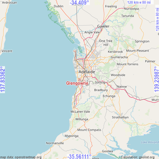
Glengowrie GPS coordinates[2]
34° 59' 13.488" South, 138° 32' 12.264" East
| Map corner | latitude | longitude |
|---|---|---|
| Upper-left | -34.409°, | 137.83362° |
| Center: | -34.98708°, | 138.53674° |
| Lower-right: | -35.56111°, | 139.23987° |
| Map W x H: | 128.1×128.1 km | = 79.6×79.6mi |
| max Lat: | -10.58257° ⇑71% North |
| Glengowrie: | -34.98708° |
| min Lat: | ⇓29% South -43.31423° |
| min Long | Glengowrie | max Long |
| 113.53327° | 138.53674° | 153.61246° |
| W 16.6%⇐ | ⇒83.4% E |
Elevation
Elevation of Glengowrie is 18 m = 59 ft, and this is 104 m = 341 ft below average elevation for this country.
| Max E: |
1715 m = 5627 ft | 76.1% |
| Avg. | 122 m = 400 ft | |
| Glengowrie | 18 m = 59 ft | |
Min E: |
-2 m = -7 ft | 23.9% |
See also: Australia elevation on elevation.city.
Geographical zone
Glengowrie is located in South temperate zone (between Tropic of Capricorn and the Antarctic Circle). Distance of this Southern Tropic circle is 1284.3 km =798 mi to North.| Distance of | km | miles | from Glengowrie |
|---|---|---|---|
| Equator | 3890.2 | 2417.3 | to North |
| Tropic Capricorn | 1284.3 | 798 | to North |
| Antarctic Circle | 3511 | 2181.6 | to South |
| South Pole | 6116.9 | 3800.9 | to South |


Nearby cities:
15 places around Glengowrie: (largest is in red/bold)
• Ascot Park
2 km =1.2 mi,  105°
105°
• Camden Park
2.1 km =1.3 mi,  7°
7°
• Glenelg
2.1 km =1.3 mi,  289°
289°
• Glenelg East
1.4 km =0.9 mi,  331°
331°
• Glenelg South
2.1 km =1.3 mi,  262°
262°
• Marion
2.4 km =1.5 mi,  141°
141°
• Morphettville
0.3 km =0.2 mi,  119°
119°
• North Brighton
2.2 km =1.4 mi,  217°
217°
• Novar Gardens
2.3 km =1.4 mi,  350°
350°
• Oaklands Park
2.3 km =1.4 mi,  161°
161°
• Park Holme
1.7 km =1.1 mi, 118°
• Plympton Park
1.3 km =0.8 mi,  57°
57°
• Somerton Park
1.8 km =1.1 mi,  231°
231°
• South Plympton
2.1 km =1.3 mi, 56°
• Warradale
1.2 km =0.7 mi,  202°
202°
Sources, notices
• [Note1] Compared only with cities in Australia existing in our database
• [Src1] Map data: © OpenStreetMap contributors (CC-BY-SA)
• [Src2] Other city data from geonames.org with taken over terms of usage.
• [Src3] Geographical zone / Annual Mean Temperature by Robert A. Rohde @ Wikipedia
