Keswick geodata
Keswick (South Australia) is a section of populated place; located in Australia in Australia/Adelaide (GMT+10.5) time zone. With population of 746 people, there are 4247 cities with bigger population in this country. Compared to other cities in Australia, 69.6% of cities are located further ↑North; 82.2% of cities are located further →East and 65.9% of cities have higher elevation than Keswick. Note1


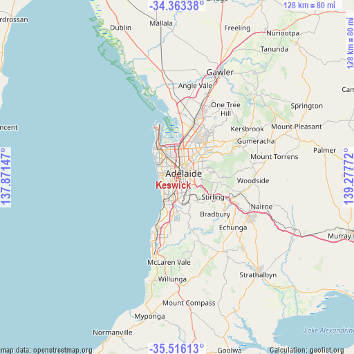
Keswick GPS coordinates[2]
34° 56' 30.408" South, 138° 34' 28.524" East
| Map corner | latitude | longitude |
|---|---|---|
| Upper-left | -34.36338°, | 137.87147° |
| Center: | -34.94178°, | 138.57459° |
| Lower-right: | -35.51613°, | 139.27772° |
| Map W x H: | 128.2×128.2 km | = 79.7×79.7mi |
| max Lat: | -10.58257° ⇑69.6% North |
| Keswick: | -34.94178° |
| min Lat: | ⇓30.4% South -43.31423° |
| min Long | Keswick | max Long |
| 113.53327° | 138.57459° | 153.61246° |
| W 17.8%⇐ | ⇒82.2% E |
Elevation
Elevation of Keswick is 26 m = 85 ft, and this is 96 m = 315 ft below average elevation for this country.
| Max E: |
1715 m = 5627 ft | 65.9% |
| Avg. | 122 m = 400 ft | |
| Keswick | 26 m = 85 ft | |
Min E: |
-2 m = -7 ft | 34.1% |
See also: Australia elevation on elevation.city.
Geographical zone
Keswick is located in South temperate zone (between Tropic of Capricorn and the Antarctic Circle). Distance of this Southern Tropic circle is 1279.2 km =794.9 mi to North.| Distance of | km | miles | from Keswick |
|---|---|---|---|
| Equator | 3885.2 | 2414.2 | to North |
| Tropic Capricorn | 1279.2 | 794.9 | to North |
| Antarctic Circle | 3516 | 2184.7 | to South |
| South Pole | 6121.9 | 3804 | to South |


Nearby cities:
15 places around Keswick: (largest is in red/bold)
• Ashford
0.8 km =0.5 mi,  180°
180°
• Black Forest
2.1 km =1.3 mi,  174°
174°
• Cowandilla
1.8 km =1.1 mi,  307°
307°
• Everard Park
1.1 km =0.7 mi, 178°
• Forestville
0.9 km =0.6 mi,  157°
157°
• Glandore
2.3 km =1.4 mi,  194°
194°
• Goodwood
1.9 km =1.2 mi,  122°
122°
• Hilton
1.4 km =0.9 mi,  319°
319°
• Kurralta Park
1.3 km =0.8 mi,  212°
212°
• Marleston
1.5 km =0.9 mi,  244°
244°
• Mile End
1.7 km =1.1 mi,  347°
347°
• Millswood
2 km =1.2 mi,  138°
138°
• Richmond
1 km =0.6 mi,  268°
268°
• Wayville
1.6 km =1 mi,  101°
101°
• Westrichmond
2.1 km =1.3 mi,  279°
279°
Sources, notices
• [Note1] Compared only with cities in Australia existing in our database
• [Src1] Map data: © OpenStreetMap contributors (CC-BY-SA)
• [Src2] Other city data from geonames.org with taken over terms of usage.
• [Src3] Geographical zone / Annual Mean Temperature by Robert A. Rohde @ Wikipedia
