Williamtown geodata
Williamtown (New South Wales) is a section of populated place; located in Australia in Australia/Sydney (GMT+11) time zone. With population of 1,091 people, there are 3708 cities with bigger population in this country. Compared to other cities in Australia, 59.6% of cities are located further ↓South; 81.5% of cities are located further ←West and 95.5% of cities have higher elevation than Williamtown. Note1


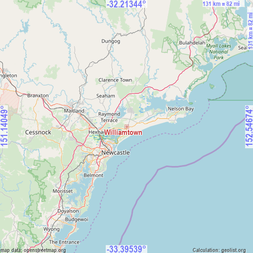
Williamtown GPS coordinates[2]
32° 48' 22.968" South, 151° 50' 36.996" East
| Map corner | latitude | longitude |
|---|---|---|
| Upper-left | -32.21344°, | 151.14049° |
| Center: | -32.80638°, | 151.84361° |
| Lower-right: | -33.39539°, | 152.54674° |
| Map W x H: | 131.4×131.4 km | = 81.6×81.6mi |
| max Lat: | -10.58257° ⇑40.4% North |
| Williamtown: | -32.80638° |
| min Lat: | ⇓59.6% South -43.31423° |
| min Long | Williamtown | max Long |
| 113.53327° | 151.84361° | 153.61246° |
| W 81.5%⇐ | ⇒18.5% E |
Elevation
Elevation of Williamtown is 6 m = 20 ft, and this is 116 m = 381 ft below average elevation for this country.
| Max E: |
1715 m = 5627 ft | 95.5% |
| Avg. | 122 m = 400 ft | |
| Williamtown | 6 m = 20 ft | |
Min E: |
-2 m = -7 ft | 4.5% |
See also: Australia elevation on elevation.city.
Geographical zone
Williamtown is located in South temperate zone (between Tropic of Capricorn and the Antarctic Circle). Distance of this Southern Tropic circle is 1041.8 km =647.3 mi to North.| Distance of | km | miles | from Williamtown |
|---|---|---|---|
| Equator | 3647.7 | 2266.6 | to North |
| Tropic Capricorn | 1041.8 | 647.3 | to North |
| Antarctic Circle | 3753.4 | 2332.3 | to South |
| South Pole | 6359.3 | 3951.5 | to South |


Nearby cities:
15 places around Williamtown: (largest is in red/bold)
• Carrington
14.2 km =8.8 mi,  211°
211°
• Fern Bay
7 km =4.3 mi,  203°
203°
• Fullerton Cove
3.8 km =2.4 mi,  187°
187°
• Heatherbrae
10.3 km =6.4 mi,  280°
280°
• Maryville
14.3 km =8.9 mi,  215°
215°
• Mayfield
14.3 km =8.9 mi, 224°
• Mayfield East
13.6 km =8.5 mi, 220°
• Mayfield West
14.5 km =9 mi,  228°
228°
• Medowie
7.6 km =4.7 mi,  17°
17°
• Nelsons Plains
12.1 km =7.5 mi,  302°
302°
• Newcastle East
14.4 km =8.9 mi, 200°
• Raymond Terrace
10.1 km =6.3 mi, 300°
• Salt Ash
7.3 km =4.5 mi,  69°
69°
• Stockton
12.7 km =7.9 mi, 206°
• Tighes Hill
14.2 km =8.8 mi, 217°
Sources, notices
• [Note1] Compared only with cities in Australia existing in our database
• [Src1] Map data: © OpenStreetMap contributors (CC-BY-SA)
• [Src2] Other city data from geonames.org with taken over terms of usage.
• [Src3] Geographical zone / Annual Mean Temperature by Robert A. Rohde @ Wikipedia
