Maryville geodata
Maryville (New South Wales) is a section of populated place; located in Australia in Australia/Sydney (GMT+11) time zone. With population of 1,409 people, there are 3357 cities with bigger population in this country. Compared to other cities in Australia, 58.8% of cities are located further ↓South; 81.2% of cities are located further ←West and 99.1% of cities have higher elevation than Maryville. Note1


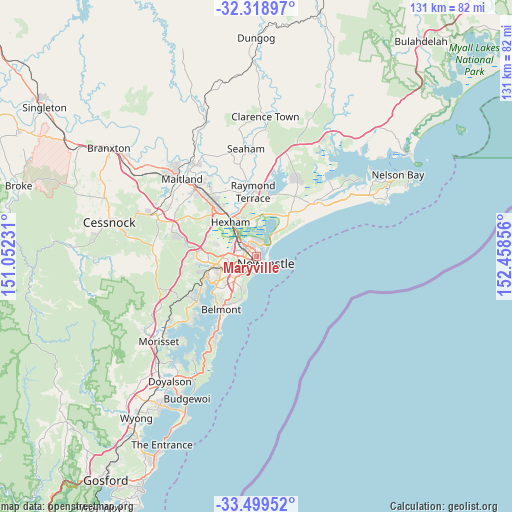
Maryville GPS coordinates[2]
32° 54' 40.356" South, 151° 45' 19.548" East
| Map corner | latitude | longitude |
|---|---|---|
| Upper-left | -32.31897°, | 151.05231° |
| Center: | -32.91121°, | 151.75543° |
| Lower-right: | -33.49952°, | 152.45856° |
| Map W x H: | 131.3×131.3 km | = 81.6×81.6mi |
| max Lat: | -10.58257° ⇑41.2% North |
| Maryville: | -32.91121° |
| min Lat: | ⇓58.8% South -43.31423° |
| min Long | Maryville | max Long |
| 113.53327° | 151.75543° | 153.61246° |
| W 81.2%⇐ | ⇒18.8% E |
Elevation
Elevation of Maryville is 2 m = 7 ft, and this is 120 m = 394 ft below average elevation for this country.
| Max E: |
1715 m = 5627 ft | 99.1% |
| Avg. | 122 m = 400 ft | |
| Maryville | 2 m = 7 ft | |
Min E: |
-2 m = -7 ft | 0.9% |
See also: Australia elevation on elevation.city.
Geographical zone
Maryville is located in South temperate zone (between Tropic of Capricorn and the Antarctic Circle). Distance of this Southern Tropic circle is 1053.5 km =654.6 mi to North.| Distance of | km | miles | from Maryville |
|---|---|---|---|
| Equator | 3659.4 | 2273.8 | to North |
| Tropic Capricorn | 1053.5 | 654.6 | to North |
| Antarctic Circle | 3741.8 | 2325 | to South |
| South Pole | 6347.7 | 3944.3 | to South |


Nearby cities:
15 places around Maryville: (largest is in red/bold)
• Carrington
0.9 km =0.6 mi,  116°
116°
• Cooks Hill
2.8 km =1.7 mi,  148°
148°
• Georgetown
2.3 km =1.4 mi,  278°
278°
• Hamilton
1.4 km =0.9 mi,  212°
212°
• Hamilton East
1.6 km =1 mi,  186°
186°
• Hamilton North
1.7 km =1.1 mi,  267°
267°
• Islington
0.8 km =0.5 mi,  248°
248°
• Mayfield
2.3 km =1.4 mi,  309°
309°
• Mayfield East
1.3 km =0.8 mi,  336°
336°
• Newcastle West
1.5 km =0.9 mi,  173°
173°
• Newcastle city centre
2.8 km =1.7 mi,  133°
133°
• Stockton
2.6 km =1.6 mi,  84°
84°
• Tighes Hill
0.6 km =0.4 mi,  315°
315°
• Waratah
2.8 km =1.7 mi, 280°
• Wickham
0.9 km =0.6 mi, 171°
Sources, notices
• [Note1] Compared only with cities in Australia existing in our database
• [Src1] Map data: © OpenStreetMap contributors (CC-BY-SA)
• [Src2] Other city data from geonames.org with taken over terms of usage.
• [Src3] Geographical zone / Annual Mean Temperature by Robert A. Rohde @ Wikipedia
