Warrandyte geodata
Warrandyte (Victoria) is a section of populated place; located in Australia in Australia/Melbourne (GMT+11) time zone. With population of 5,368 people, there are 1386 cities with bigger population in this country. Compared to other cities in Australia, 86.1% of cities are located further ↑North; 62.3% of cities are located further →East and 65.9% of cities have lower elevation than Warrandyte. Note1


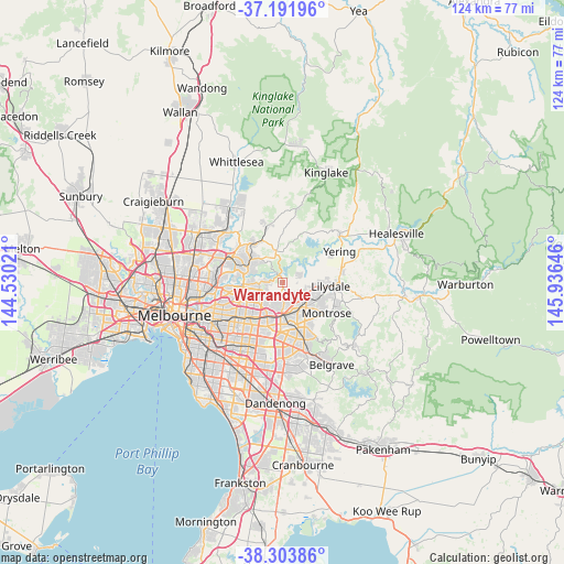
Warrandyte GPS coordinates[2]
37° 45' 0" South, 145° 13' 59.988" East
| Map corner | latitude | longitude |
|---|---|---|
| Upper-left | -37.19196°, | 144.53021° |
| Center: | -37.75°, | 145.23333° |
| Lower-right: | -38.30386°, | 145.93646° |
| Map W x H: | 123.6×123.6 km | = 76.8×76.8mi |
| max Lat: | -10.58257° ⇑86.1% North |
| Warrandyte: | -37.75° |
| min Lat: | ⇓13.9% South -43.31423° |
| min Long | Warrandyte | max Long |
| 113.53327° | 145.23333° | 153.61246° |
| W 37.7%⇐ | ⇒62.3% E |
Elevation
Elevation of Warrandyte is 83 m = 272 ft, and this is 39 m = 128 ft below average elevation for this country.
| Max E: |
1715 m = 5627 ft | 34.1% |
| Avg. | 122 m = 400 ft | |
| Warrandyte | 83 m = 272 ft | |
Min E: |
-2 m = -7 ft | 65.9% |
See also: Australia elevation on elevation.city.
Geographical zone
Warrandyte is located in South temperate zone (between Tropic of Capricorn and the Antarctic Circle). Distance of this Southern Tropic circle is 1591.5 km =988.9 mi to North.| Distance of | km | miles | from Warrandyte |
|---|---|---|---|
| Equator | 4197.4 | 2608.1 | to North |
| Tropic Capricorn | 1591.5 | 988.9 | to North |
| Antarctic Circle | 3203.8 | 1990.7 | to South |
| South Pole | 5809.7 | 3610 | to South |


Nearby cities:
15 places around Warrandyte: (largest is in red/bold)
• Chirnside Park
7.2 km =4.5 mi,  79°
79°
• Croydon
7.1 km =4.4 mi,  141°
141°
• Croydon Hills
4 km =2.5 mi, 137°
• Croydon North
5.4 km =3.4 mi,  110°
110°
• Donvale
6.7 km =4.2 mi,  229°
229°
• Kangaroo Ground
6.8 km =4.2 mi,  358°
358°
• North Warrandyte
2.8 km =1.7 mi,  326°
326°
• Park Orchards
3.4 km =2.1 mi,  208°
208°
• Research
7.1 km =4.4 mi,  321°
321°
• Ringwood
7.4 km =4.6 mi,  180°
180°
• Ringwood North
5.6 km =3.5 mi, 180°
• Templestowe
7.5 km =4.7 mi,  266°
266°
• Warrandyte South
1.4 km =0.9 mi,  131°
131°
• Warranwood
3.1 km =1.9 mi,  156°
156°
• Wonga Park
3.5 km =2.2 mi,  57°
57°
Sources, notices
• [Note1] Compared only with cities in Australia existing in our database
• [Src1] Map data: © OpenStreetMap contributors (CC-BY-SA)
• [Src2] Other city data from geonames.org with taken over terms of usage.
• [Src3] Geographical zone / Annual Mean Temperature by Robert A. Rohde @ Wikipedia
