Donvale geodata
Donvale (Victoria) is a section of populated place; located in Australia in Australia/Melbourne (GMT+11) time zone. With population of 12,076 people, there are 401 cities with bigger population in this country. Compared to other cities in Australia, 87.2% of cities are located further ↑North; 63% of cities are located further →East and 76.5% of cities have lower elevation than Donvale. Note1


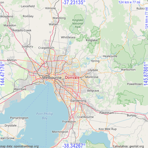
Donvale GPS coordinates[2]
37° 47' 20.76" South, 145° 10' 29.568" East
| Map corner | latitude | longitude |
|---|---|---|
| Upper-left | -37.23135°, | 144.47176° |
| Center: | -37.7891°, | 145.17488° |
| Lower-right: | -38.34267°, | 145.87801° |
| Map W x H: | 123.6×123.6 km | = 76.8×76.8mi |
| max Lat: | -10.58257° ⇑87.2% North |
| Donvale: | -37.7891° |
| min Lat: | ⇓12.8% South -43.31423° |
| min Long | Donvale | max Long |
| 113.53327° | 145.17488° | 153.61246° |
| W 37%⇐ | ⇒63% E |
Elevation
Elevation of Donvale is 143 m = 469 ft, and this is 21 m = 69 ft above average elevation for this country.
| Max E: |
1715 m = 5627 ft | 23.5% |
| Donvale | 143 m 469 ft | |
| Avg. | 122 m = 400 ft | |
Min E: |
-2 m = -7 ft | 76.5% |
See also: Australia elevation on elevation.city.
Geographical zone
Donvale is located in South temperate zone (between Tropic of Capricorn and the Antarctic Circle). Distance of this Southern Tropic circle is 1595.8 km =991.6 mi to North.| Distance of | km | miles | from Donvale |
|---|---|---|---|
| Equator | 4201.8 | 2610.9 | to North |
| Tropic Capricorn | 1595.8 | 991.6 | to North |
| Antarctic Circle | 3199.4 | 1988 | to South |
| South Pole | 5805.3 | 3607.2 | to South |


Nearby cities:
15 places around Donvale: (largest is in red/bold)
• Blackburn
3.8 km =2.4 mi,  209°
209°
• Blackburn North
3 km =1.9 mi,  222°
222°
• Blackburn South
5.9 km =3.7 mi,  196°
196°
• Box Hill
5.5 km =3.4 mi,  232°
232°
• Box Hill North
4.5 km =2.8 mi,  250°
250°
• Doncaster
4.5 km =2.8 mi,  271°
271°
• Doncaster East
2.3 km =1.4 mi, 274°
• Forest Hill
5 km =3.1 mi,  171°
171°
• Mitcham
3.8 km =2.4 mi,  144°
144°
• Nunawading
3.5 km =2.2 mi,  182°
182°
• Park Orchards
3.7 km =2.3 mi,  68°
68°
• Ringwood North
5.3 km =3.3 mi,  103°
103°
• Templestowe
4.5 km =2.8 mi,  329°
329°
• Templestowe Lower
5.7 km =3.5 mi,  295°
295°
• Vermont
5.5 km =3.4 mi,  161°
161°
Sources, notices
• [Note1] Compared only with cities in Australia existing in our database
• [Src1] Map data: © OpenStreetMap contributors (CC-BY-SA)
• [Src2] Other city data from geonames.org with taken over terms of usage.
• [Src3] Geographical zone / Annual Mean Temperature by Robert A. Rohde @ Wikipedia
