Urangan geodata
Urangan (Queensland) is a section of populated place; located in Australia in Australia/Brisbane (GMT+10) time zone. With population of 10,758 people, there are 511 cities with bigger population in this country. Compared to other cities in Australia, 89.2% of cities are located further ↓South; 88.6% of cities are located further ←West and 86.8% of cities have higher elevation than Urangan. Note1


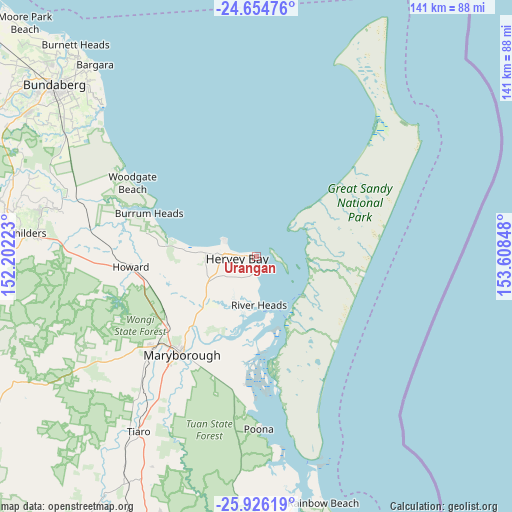
Urangan GPS coordinates[2]
25° 17' 31.704" South, 152° 54' 19.26" East
| Map corner | latitude | longitude |
|---|---|---|
| Upper-left | -24.65476°, | 152.20223° |
| Center: | -25.29214°, | 152.90535° |
| Lower-right: | -25.92619°, | 153.60848° |
| Map W x H: | 141.4×141.4 km | = 87.9×87.9mi |
| max Lat: | -10.58257° ⇑10.8% North |
| Urangan: | -25.29214° |
| min Lat: | ⇓89.2% South -43.31423° |
| min Long | Urangan | max Long |
| 113.53327° | 152.90535° | 153.61246° |
| W 88.6%⇐ | ⇒11.4% E |
Elevation
Elevation of Urangan is 11 m = 36 ft, and this is 111 m = 364 ft below average elevation for this country.
| Max E: |
1715 m = 5627 ft | 86.8% |
| Avg. | 122 m = 400 ft | |
| Urangan | 11 m = 36 ft | |
Min E: |
-2 m = -7 ft | 13.2% |
See also: Australia elevation on elevation.city.
Geographical zone
Urangan is located in South temperate zone (between Tropic of Capricorn and the Antarctic Circle). Distance of this Southern Tropic circle is 206.3 km =128.2 mi to North.| Distance of | km | miles | from Urangan |
|---|---|---|---|
| Equator | 2812.2 | 1747.4 | to North |
| Tropic Capricorn | 206.3 | 128.2 | to North |
| Antarctic Circle | 4589 | 2851.5 | to South |
| South Pole | 7194.8 | 4470.6 | to South |


Nearby cities:
15 places around Urangan: (largest is in red/bold)
• Booral
7.6 km =4.7 mi,  177°
177°
• Dundowran
13.2 km =8.2 mi,  268°
268°
• Dundowran Beach
14.6 km =9.1 mi,  279°
279°
• Eli Waters
9.8 km =6.1 mi, 278°
• Hervey Bay
13.7 km =8.5 mi, 272°
• Kawungan
6 km =3.7 mi,  262°
262°
• Nikenbah
10.6 km =6.6 mi,  253°
253°
• Pialba
6.2 km =3.9 mi, 275°
• Point Vernon
9.7 km =6 mi,  293°
293°
• River Heads
13.7 km =8.5 mi, 176°
• Scarness
5 km =3.1 mi, 280°
• Sunshine Acres
13.9 km =8.6 mi,  238°
238°
• Torquay
2.8 km =1.7 mi, 286°
• Urraween
8.4 km =5.2 mi, 267°
• Wondunna
5.4 km =3.4 mi, 238°
Sources, notices
• [Note1] Compared only with cities in Australia existing in our database
• [Src1] Map data: © OpenStreetMap contributors (CC-BY-SA)
• [Src2] Other city data from geonames.org with taken over terms of usage.
• [Src3] Geographical zone / Annual Mean Temperature by Robert A. Rohde @ Wikipedia
