Upper Brookfield geodata
Upper Brookfield (Queensland) is a section of populated place; located in Australia in Australia/Brisbane (GMT+10) time zone. With population of 756 people, there are 4233 cities with bigger population in this country. Compared to other cities in Australia, 82.6% of cities are located further ↓South; 88% of cities are located further ←West and 81.1% of cities have lower elevation than Upper Brookfield. Note1


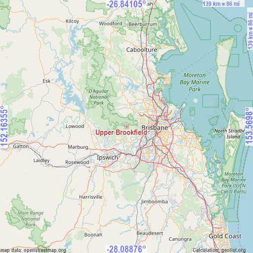
Upper Brookfield GPS coordinates[2]
27° 28' 0.012" South, 152° 52' 0.012" East
| Map corner | latitude | longitude |
|---|---|---|
| Upper-left | -26.84105°, | 152.16355° |
| Center: | -27.46667°, | 152.86667° |
| Lower-right: | -28.08876°, | 153.5698° |
| Map W x H: | 138.7×138.7 km | = 86.2×86.2mi |
| max Lat: | -10.58257° ⇑17.4% North |
| Upper Brookfield: | -27.46667° |
| min Lat: | ⇓82.6% South -43.31423° |
| min Long | Upper Brookfiel | max Long |
| 113.53327° | 152.86667° | 153.61246° |
| W 88%⇐ | ⇒12% E |
Elevation
Elevation of Upper Brookfield is 193 m = 633 ft, and this is 71 m = 233 ft above average elevation for this country.
| Max E: |
1715 m = 5627 ft | 18.9% |
| Upper Brookfield | 193 m 633 ft | |
| Avg. | 122 m = 400 ft | |
Min E: |
-2 m = -7 ft | 81.1% |
See also: Australia elevation on elevation.city.
Geographical zone
Upper Brookfield is located in South temperate zone (between Tropic of Capricorn and the Antarctic Circle). Distance of this Southern Tropic circle is 448.1 km =278.4 mi to North.| Distance of | km | miles | from Upper Brookfield |
|---|---|---|---|
| Equator | 3054 | 1897.7 | to North |
| Tropic Capricorn | 448.1 | 278.4 | to North |
| Antarctic Circle | 4347.2 | 2701.2 | to South |
| South Pole | 6953.1 | 4320.5 | to South |


Nearby cities:
15 places around Upper Brookfield: (largest is in red/bold)
• Anstead
7.9 km =4.9 mi,  183°
183°
• Brookfield
5 km =3.1 mi,  138°
138°
• Camp Mountain
7.6 km =4.7 mi,  12°
12°
• Chapel Hill
9.2 km =5.7 mi,  115°
115°
• Ferny Grove
9.9 km =6.2 mi,  42°
42°
• Kenmore
8.4 km =5.2 mi, 122°
• Kenmore Hills
7.7 km =4.8 mi, 122°
• Keperra
9.9 km =6.2 mi,  53°
53°
• Mount Crosby
10.1 km =6.3 mi,  216°
216°
• Pinjarra Hills
8.9 km =5.5 mi,  153°
153°
• Pullenvale
6.5 km =4 mi,  162°
162°
• The Gap
7.6 km =4.7 mi,  68°
68°
• Upper Kedron
7.3 km =4.5 mi, 43°
• Westlake
10.2 km =6.3 mi, 153°
• Wights Mountain
8.2 km =5.1 mi,  352°
352°
Sources, notices
• [Note1] Compared only with cities in Australia existing in our database
• [Src1] Map data: © OpenStreetMap contributors (CC-BY-SA)
• [Src2] Other city data from geonames.org with taken over terms of usage.
• [Src3] Geographical zone / Annual Mean Temperature by Robert A. Rohde @ Wikipedia
