Brookfield geodata
Brookfield (Queensland) is a section of populated place; located in Australia in Australia/Brisbane (GMT+10) time zone. With population of 3,446 people, there are 2009 cities with bigger population in this country. Compared to other cities in Australia, 81.9% of cities are located further ↓South; 88.5% of cities are located further ←West and 72.3% of cities have lower elevation than Brookfield. Note1


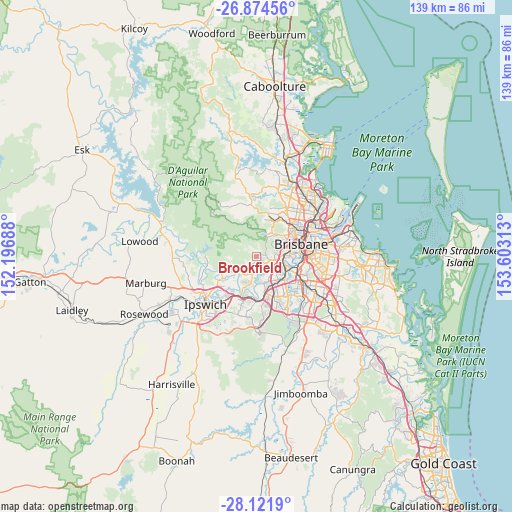
Brookfield GPS coordinates[2]
27° 30' 0" South, 152° 54' 0" East
| Map corner | latitude | longitude |
|---|---|---|
| Upper-left | -26.87456°, | 152.19688° |
| Center: | -27.5°, | 152.9° |
| Lower-right: | -28.1219°, | 153.60313° |
| Map W x H: | 138.7×138.7 km | = 86.2×86.2mi |
| max Lat: | -10.58257° ⇑18.1% North |
| Brookfield: | -27.5° |
| min Lat: | ⇓81.9% South -43.31423° |
| min Long | Brookfield | max Long |
| 113.53327° | 152.9° | 153.61246° |
| W 88.5%⇐ | ⇒11.5% E |
Elevation
Elevation of Brookfield is 114 m = 374 ft, and this is 8 m = 26 ft below average elevation for this country.
| Max E: |
1715 m = 5627 ft | 27.7% |
| Avg. | 122 m = 400 ft | |
| Brookfield | 114 m = 374 ft | |
Min E: |
-2 m = -7 ft | 72.3% |
See also: Australia elevation on elevation.city.
Geographical zone
Brookfield is located in South temperate zone (between Tropic of Capricorn and the Antarctic Circle). Distance of this Southern Tropic circle is 451.8 km =280.7 mi to North.| Distance of | km | miles | from Brookfield |
|---|---|---|---|
| Equator | 3057.7 | 1900 | to North |
| Tropic Capricorn | 451.8 | 280.7 | to North |
| Antarctic Circle | 4343.5 | 2698.9 | to South |
| South Pole | 6949.3 | 4318.1 | to South |


Nearby cities:
15 places around Brookfield: (largest is in red/bold)
• Anstead
5.6 km =3.5 mi,  221°
221°
• Bellbowrie
6.8 km =4.2 mi,  194°
194°
• Chapel Hill
5 km =3.1 mi,  93°
93°
• Fig Tree Pocket
6.8 km =4.2 mi,  116°
116°
• Jindalee
5.4 km =3.4 mi,  135°
135°
• Kenmore
3.9 km =2.4 mi,  102°
102°
• Kenmore Hills
3.2 km =2 mi, 98°
• Middle Park
6.6 km =4.1 mi,  160°
160°
• Mount Ommaney
6 km =3.7 mi,  148°
148°
• Pinjarra Hills
4.3 km =2.7 mi,  170°
170°
• Pullenvale
2.9 km =1.8 mi,  207°
207°
• Riverhills
6.7 km =4.2 mi, 170°
• Sinnamon Park
6.9 km =4.3 mi, 135°
• Upper Brookfield
5 km =3.1 mi,  318°
318°
• Westlake
5.6 km =3.5 mi, 166°
Sources, notices
• [Note1] Compared only with cities in Australia existing in our database
• [Src1] Map data: © OpenStreetMap contributors (CC-BY-SA)
• [Src2] Other city data from geonames.org with taken over terms of usage.
• [Src3] Geographical zone / Annual Mean Temperature by Robert A. Rohde @ Wikipedia
