Tully geodata
Tully (Queensland) is a populated place; located in Australia in Australia/Brisbane (GMT+10) time zone. With population of 2,431 people, there are 2608 cities with bigger population in this country. Compared to other cities in Australia, 96.2% of cities are located further ↓South; 57.4% of cities are located further →East and 56.9% of cities have higher elevation than Tully. Note1


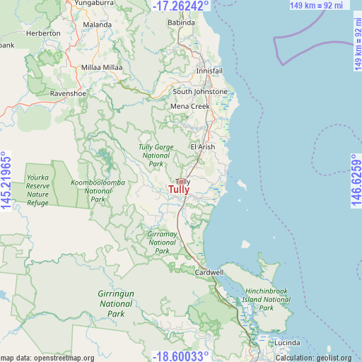
Tully GPS coordinates[2]
17° 55' 57.504" South, 145° 55' 21.972" East
| Map corner | latitude | longitude |
|---|---|---|
| Upper-left | -17.26242°, | 145.21965° |
| Center: | -17.93264°, | 145.92277° |
| Lower-right: | -18.60033°, | 146.6259° |
| Map W x H: | 148.8×148.8 km | = 92.5×92.5mi |
| max Lat: | -10.58257° ⇑3.8% North |
| Tully: | -17.93264° |
| min Lat: | ⇓96.2% South -43.31423° |
| min Long | Tully | max Long |
| 113.53327° | 145.92277° | 153.61246° |
| W 42.6%⇐ | ⇒57.4% E |
Elevation
Elevation of Tully is 36 m = 118 ft, and this is 86 m = 282 ft below average elevation for this country.
| Max E: |
1715 m = 5627 ft | 56.9% |
| Avg. | 122 m = 400 ft | |
| Tully | 36 m = 118 ft | |
Min E: |
-2 m = -7 ft | 43.1% |
See also: Australia elevation on elevation.city.
Geographical zone
Tully is located in South Torrid zone (between Equator and Tropic of Capricorn). Distance of this Southern Tropic circle is 612 km =380.3 mi to South.| Distance of | km | miles | from Tully |
|---|---|---|---|
| Equator | 1993.9 | 1239 | to North |
| Tropic Capricorn | 612 | 380.3 | to South |
| Antarctic Circle | 5407.3 | 3359.9 | to South |
| South Pole | 8013.1 | 4979.1 | to South |


Nearby cities:
15 places around Tully: (largest is in red/bold)
• Belvedere
46.2 km =28.7 mi,  8°
8°
• Cardwell
38.8 km =24.1 mi,  163°
163°
• Cullinane
48.1 km =29.9 mi, 12°
• East Innisfail
46 km =28.6 mi, 14°
• Goondi Bend
47.1 km =29.3 mi, 11°
• Goondi Hill
46 km =28.6 mi, 12°
• Innisfail
47.1 km =29.3 mi, 14°
• Innisfail Estate
47.8 km =29.7 mi,  15°
15°
• Kurrimine Beach
26.1 km =16.2 mi,  47°
47°
• Millaa Millaa
57 km =35.4 mi,  324°
324°
• Mission Beach
20.4 km =12.7 mi,  69°
69°
• Mourilyan
41 km =25.5 mi, 18°
• South Mission Beach
17.1 km =10.6 mi,  96°
96°
• Wangan
40.5 km =25.2 mi, 12°
• Wongaling Beach
18.5 km =11.5 mi,  83°
83°
Sources, notices
• [Note1] Compared only with cities in Australia existing in our database
• [Src1] Map data: © OpenStreetMap contributors (CC-BY-SA)
• [Src2] Other city data from geonames.org with taken over terms of usage.
• [Src3] Geographical zone / Annual Mean Temperature by Robert A. Rohde @ Wikipedia
