Toowoomba geodata
Toowoomba (Queensland) is a populated place; located in Australia in Australia/Brisbane (GMT+10) time zone. With population of 131,258 people, there are 14 cities with bigger population in this country. Compared to other cities in Australia, 80.4% of cities are located further ↓South; 82.2% of cities are located further ←West and 95.8% of cities have lower elevation than Toowoomba. Note1


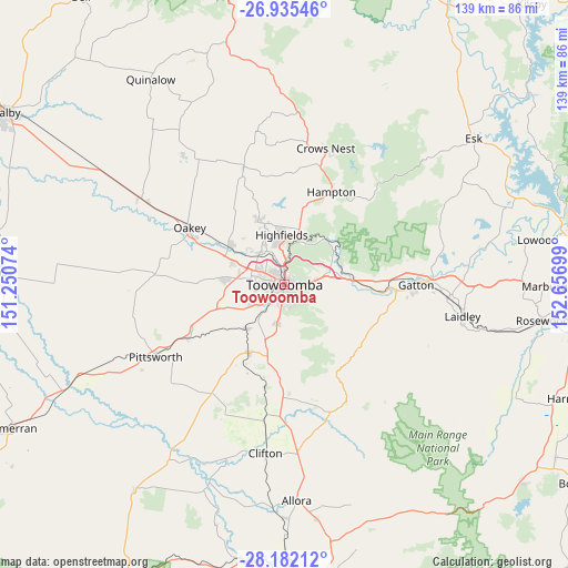
Toowoomba GPS coordinates[2]
27° 33' 38.016" South, 151° 57' 13.896" East
| Map corner | latitude | longitude |
|---|---|---|
| Upper-left | -26.93546°, | 151.25074° |
| Center: | -27.56056°, | 151.95386° |
| Lower-right: | -28.18212°, | 152.65699° |
| Map W x H: | 138.6×138.6 km | = 86.1×86.1mi |
| max Lat: | -10.58257° ⇑19.6% North |
| Toowoomba: | -27.56056° |
| min Lat: | ⇓80.4% South -43.31423° |
| min Long | Toowoomba | max Long |
| 113.53327° | 151.95386° | 153.61246° |
| W 82.2%⇐ | ⇒17.8% E |
Elevation
Elevation of Toowoomba is 599 m = 1965 ft, and this is 477 m = 1565 ft above average elevation for this country.
| Max E: |
1715 m = 5627 ft | 4.2% |
| Toowoomba | 599 m 1965 ft | |
| Avg. | 122 m = 400 ft | |
Min E: |
-2 m = -7 ft | 95.8% |
See also: Toowoomba elevation on elevation.city.
Geographical zone
Toowoomba is located in South temperate zone (between Tropic of Capricorn and the Antarctic Circle). Distance of this Southern Tropic circle is 458.5 km =284.9 mi to North.| Distance of | km | miles | from Toowoomba |
|---|---|---|---|
| Equator | 3064.4 | 1904.1 | to North |
| Tropic Capricorn | 458.5 | 284.9 | to North |
| Antarctic Circle | 4336.7 | 2694.7 | to South |
| South Pole | 6942.6 | 4313.9 | to South |


Nearby cities:
15 places around Toowoomba: (largest is in red/bold)
• Centenary Heights
3 km =1.9 mi,  163°
163°
• Darling Heights
4.6 km =2.9 mi,  209°
209°
• East Toowoomba
2.3 km =1.4 mi,  119°
119°
• Harlaxton
3.3 km =2.1 mi,  22°
22°
• Harristown
3.2 km =2 mi,  218°
218°
• Kearneys Spring
5.1 km =3.2 mi,  194°
194°
• Mount Lofty
2.4 km =1.5 mi,  48°
48°
• Newtown
2.2 km =1.4 mi,  283°
283°
• North Toowoomba
2 km =1.2 mi, 21°
• Prince Henry Heights
3.8 km =2.4 mi,  73°
73°
• Rangeville
3.6 km =2.2 mi,  134°
134°
• Rockville
3.1 km =1.9 mi,  330°
330°
• South Toowoomba
1.4 km =0.9 mi, 211°
• Wilsonton
4.1 km =2.5 mi,  297°
297°
• Wilsonton Heights
4.3 km =2.7 mi,  317°
317°
Sources, notices
• [Note1] Compared only with cities in Australia existing in our database
• [Src1] Map data: © OpenStreetMap contributors (CC-BY-SA)
• [Src2] Other city data from geonames.org with taken over terms of usage.
• [Src3] Geographical zone / Annual Mean Temperature by Robert A. Rohde @ Wikipedia
