Toolooa geodata
Toolooa (Queensland) is a section of populated place; located in Australia in Australia/Brisbane (GMT+10) time zone. With population of 901 people, there are 3970 cities with bigger population in this country. Compared to other cities in Australia, 90.9% of cities are located further ↓South; 75.1% of cities are located further ←West and 52.4% of cities have higher elevation than Toolooa. Note1


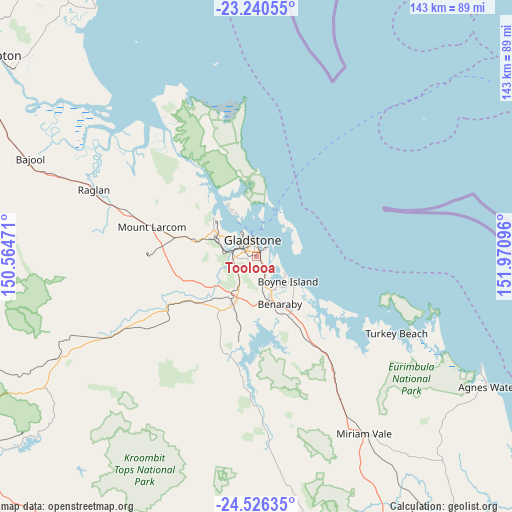
Toolooa GPS coordinates[2]
23° 53' 6.18" South, 151° 16' 4.188" East
| Map corner | latitude | longitude |
|---|---|---|
| Upper-left | -23.24055°, | 150.56471° |
| Center: | -23.88505°, | 151.26783° |
| Lower-right: | -24.52635°, | 151.97096° |
| Map W x H: | 143×143 km | = 88.9×88.9mi |
| max Lat: | -10.58257° ⇑9.1% North |
| Toolooa: | -23.88505° |
| min Lat: | ⇓90.9% South -43.31423° |
| min Long | Toolooa | max Long |
| 113.53327° | 151.26783° | 153.61246° |
| W 75.1%⇐ | ⇒24.9% E |
Elevation
Elevation of Toolooa is 42 m = 138 ft, and this is 80 m = 262 ft below average elevation for this country.
| Max E: |
1715 m = 5627 ft | 52.4% |
| Avg. | 122 m = 400 ft | |
| Toolooa | 42 m = 138 ft | |
Min E: |
-2 m = -7 ft | 47.6% |
See also: Australia elevation on elevation.city.
Geographical zone
Toolooa is located in South temperate zone (between Tropic of Capricorn and the Antarctic Circle). Distance of this Southern Tropic circle is 49.8 km =30.9 mi to North.| Distance of | km | miles | from Toolooa |
|---|---|---|---|
| Equator | 2655.8 | 1650.2 | to North |
| Tropic Capricorn | 49.8 | 30.9 | to North |
| Antarctic Circle | 4745.4 | 2948.7 | to South |
| South Pole | 7351.3 | 4567.9 | to South |


Nearby cities:
15 places around Toolooa: (largest is in red/bold)
• Barney Point
4.1 km =2.5 mi,  357°
357°
• Beecher
7.1 km =4.4 mi,  256°
256°
• Boyne Island
11.2 km =7 mi,  128°
128°
• Burua
8.9 km =5.5 mi,  215°
215°
• Clinton
5.2 km =3.2 mi,  282°
282°
• Gladstone
4.2 km =2.6 mi,  345°
345°
• Gladstone Central
5.1 km =3.2 mi,  337°
337°
• Glen Eden
1.4 km =0.9 mi,  165°
165°
• Kin Kora
2.3 km =1.4 mi,  293°
293°
• Kirkwood
3.9 km =2.4 mi,  238°
238°
• New Auckland
3.3 km =2.1 mi,  272°
272°
• South Gladstone
2.5 km =1.6 mi,  0°
0°
• Sun Valley
1.5 km =0.9 mi,  316°
316°
• Telina
1.5 km =0.9 mi, 255°
• West Gladstone
3.5 km =2.2 mi, 319°
Sources, notices
• [Note1] Compared only with cities in Australia existing in our database
• [Src1] Map data: © OpenStreetMap contributors (CC-BY-SA)
• [Src2] Other city data from geonames.org with taken over terms of usage.
• [Src3] Geographical zone / Annual Mean Temperature by Robert A. Rohde @ Wikipedia
